Showing posts with label Marilyns. Show all posts

Sunday, 27 October 2019

Lomond Hills, Fife

Approaching East Lomond
The Lomond Hills in Fife have passed me by on numerous occasions when travelling to meetings or events in St Andrews or Fife House, Glenrothes. I had always promised to stop and run them at the end of the day but time and work conspired against it. I had been looking for a decent spell of weather in the far north but nothing was doing. I noticed that Sunday was fine in Fife so I decided to make an excursion to climb them. Gregor agreed to come along and he would run them along with Bishop's Hill, and the shore path around Loch Leven to give him a 25 kilometre run to Milnathort where I would collect him. 

It was the day the clocks went back,  always a special day for the hills.  It was the weekend of the Karrimor International Mountain Marathons, which I had competed  on 13 occasions between 1976 to 1998 and the Snowdon Marathon that I ran in 1988. The extra hour meant that we could make a lazy start and still be walking or running by 9am from the Craigmead car park that sits on the saddle between West And East Lomond. There were only four cars there when we arrived. It was barely above freezing as we started out on a crystal clear morning with blue skies and a strong northerly breeze.

Sunday 27 October 2019

Lomond Hills

Ascent:     526 metres
Distance:  11 kilometres
Time:        2 hours 14 minutes

East Lomond     434m        23mins
West Lomond    522m        1hr 33mins

We decided to take in East Lomond Hill first so that Gregor could continue from West Lomond Hill to Bishop's Hill and then drop down to Loch Leven and follow the trail to Milnathort. The ice on the rocks on the initial section of the path was thawing and the first kilometre of the path was an easy pull before the final 100 metres of ascent to the summit on a grassy path. Gregor passed me on his descent at this point, the last I would see of him until Milnathort. The wind at the summit was not welcoming but it was trumped by the glorious patchwork field pattern of Fife displaying all its autumnal shades. I spent a few minutes inhaling the air and the views before descending by the same route. I passed another 3 walkers and 2 runners on their ascent.

I had intended to collect my rucsac at the car park for the ascent of West Lomond but there would be no need of it in these conditions so I stopped for some water before continuing on the longer of the two walks.  The path makes it an easy ascent, initially over short grass and then a wide stony path that climbs at a gentle gradient. The final 110 metres is the real climb and there is an option of a direct ascent up a steep path on a slightly muddy path or a half circuit of the hill at a more relaxing gradient. I chose the former and it proved no bother, I was walking well. The summit has a trig point on a stony base that seems to be eroding rapidly. The sun was higher in the sky and the views were not as clear as earlier in the day but Fife was dressed in its Sunday best. The Forth estuary provided a shimmering silver boundary to the south punctuated by Inchkeith, a perfect isosceles triangle. 

There had been few other walkers on the ascent but on the return to the car park the number of people exercising was impressive. I counted 29 women, 25 men, 12 dogs walking up the hill along with a lone runner and 6 mountain bikers. It confirmed the impression that I have had in recent years that there are as many women as men now enjoying the great outdoors and that mountain bikes make a mess of the grassy footpaths. I have no qualms about mountain bikes on tracks and hard trails but too many paths on the hills are being badly eroded by bikes. The car park at Craigmead was full as people began their walks. It was just after 11:00am and my exercise was over. I drove back to Milnathort and arrived within minutes of Gregor, we had really made the best use of the morning and we could now look forward to the Liverpool game. 

 G Descending East Lomond
East Lomond summit
Ballo Reservoir and West Lomond from East Lomond
West Lomond from East Lomond 
West Lomond ahead
West Lomond
Fife from West Lomond Hill
West Lomond and Loch Leven
Path from West Lomond
East Lomond from West Lomond path


Monday, 21 October 2019

Stronend

Stronend view to Ben Lomond and Arrochar Alps

Sunday 20 October 2019

Ascent:      410 metres
Distance:   10 kilometres
Time:         3 hours 12 mins
Stronend   511m    2hrs 25mins


Stronend is the highest point in the Eastern Campsies and visible from the house. It was time that I climbed it as it is a Marilyn as well. Gregor had run up it a month ago and said the panoramic views from Stronend of the mountains spanning from Ben Lomond to Ben Vorlich were quite stunning. However, the route from Kippen via the Boquan burn required crossing 3 kilometres of an upland peat moor on a not very reliable boggy path. He was right on both counts.

It was the sort of autumn morning that beseeches you to get out and as Gregor was going to Glasgow I got him to drop me off near Garrique Farm on the backroad to Fintry. There is an excellent track that climbs steadily alongside the Boquan burn until it breaches the continuous line of crags at the Spout of Ballochleam. The views to the north are sublime from here with the mixed woodlands and Flanders Moss rising into the highlands beyond the boundary fault. There have been several new plantations of woodland that are passed on the ascent that have been funded by the EU. As you arrive at the gate at the top of the track there is a helpful sign explaining the importance of the upland moor for carbon capture and giving a list of the bird species to be found on this hostile upland environment. 

A track continues to the Ling Hill wind farm that had 25 or so turbines whirring at a good generation speed in the strong northerly wind. I entered the boggy ground on what was the relatively unused track and headed alongside the Boquan burn for a while until the depth of the sphagnum moss and the boggy ground was impairing progress to such an extent that I decided, wrongly, to head south to reach higher ground. I had thought that this would give easier conditions but it became 45 minutes of battle with heather and sphagnum moss. It was an extreme workout for my ankles and thighs as I fell half a dozen times into the channels of bog that meandered between the tussocks of deep vegetation. I began to think that the two black kites that were circling above were awaiting my final collapse.

At last, I reached the summit plateau by the 482m spot height and from there it was an easier walk to the large block of stones at the summit. The views were all that had been promised and I spent 10 minutes or so enjoying the panorama to the north-west as I examined the map on my phone. I decided that I would try to find a route off to the west and drop down to Fintry. I was pleasantly surprised to find a notch in the crags to descend to the flank of the hill that is called Skiddaw on the OS map.

I phoned to arrange my lift home from Fintry not Kippen before following a wall that had a faint path running alongside. It curved round to the west and steepened so I decided to head straight down to the road and became trapped in a long slope of prickly gorse bushes. It required me to search out gloves before I could extricate myself from the nasty stuff. I negotiated a ditch and fence and descended through a forested area scattering some roe deer before reaching the lush grazings than ran down to the road. The descent had certainly been a lot quicker than would have been a return by the ascent route. It had also provided a fine traverse to admire the setting of the village of Fintry and observe the scarp slope of the western Campsies. On balance, the outing had been worth it but I doubt if there are any regulars for this hill.

Looking west over Kippen Moor to Ben Lomond
Ballochleam and Ben Vorlich to the north
Boquan burn cutting through the moor
Ling Hill Wind Farm from the moor
Stronend summit
Ben Venue, Ben More and Ben Ledi from Stronend
Ben Lomond from Skiddaw
West to the Campsies and Earl's Seat
Stronend showing descent route by the nick in the crags

Fintry


Friday, 15 July 2011

Foula


Co-pilot for the flight out
Westerwick

Da Town with Da Sneug in cloud


Grazing ponies below Da Noup

Cheer up its not the pits 
Puffins by the hundreds
Da Sneck o da Smaalie
High Five
Friendly Bonxie
Looking back to Da Kame from Da Clay Pool
Foula Primary School and Solar Panels
Da Toon o Ham

Marshall lands Council plane
Airport Terminal with Da Noup skimmed by cloud

My third attempt to get to Foula was a double success, the plane was running and I was allocated the coveted co-pilot's seat. The views from the cockpit were an unexpected bonus even though low cloud was settled on Da Sneug, the second-highest hill in Shetland at 418m. It is one of two Marilyns on Foula, which is the most remote inhabited island in the UK with a population of only 25. It is battered by the Atlantic and was the location for the film 'Edge of the World'. Foula means 'Bird Island' and it is a Special Protection Area (SPA) for birds, as well as a National Scenic Area and a Site of Special Scientific Interest (SSSI) for its plants and geology.

The flight passed over the spectacular west coast of Mainland Shetland with the coastline looking like a wooden jigsaw puzzle with the green green grass dappled with small lochans. We flew over Da Toon o' Ham before squirting onto the landing field where a fire engine and assembly of locals had gathered to see what and who the flight brought in. The pilot chatted to the few passengers as we disembarked before we began our adventures into the wild landscape. 

I had decided to climb the two Marilyns and walk as much of the island as I could during the five hours between flights. I headed for Da Noup first, it was lower at just 248m and was still visible below the cloud level. But first I needed some protection from the Great Skuas - the dreaded Foula Bonxies. It was still the nesting season when they were at their most aggressive against intruders. I found an old fence post at Da Hametoon and strapped it into my rucksack so that it gave me two feet of timber above my head. Compared to my usual Shetland walking partner the fencepost was an unusually quiet and loyal companion for the day and probably saved me a few maulings. The initial climb was through one of the nesting sites so it was head down and a quick ascent. By the time I reached the ridge, the traffic of low-flying bonxies had decreased but they were still patrolling the ridgeline. I hunkered down below the summit to enjoy the views of the sea and to get some peace whilst I ate some food.

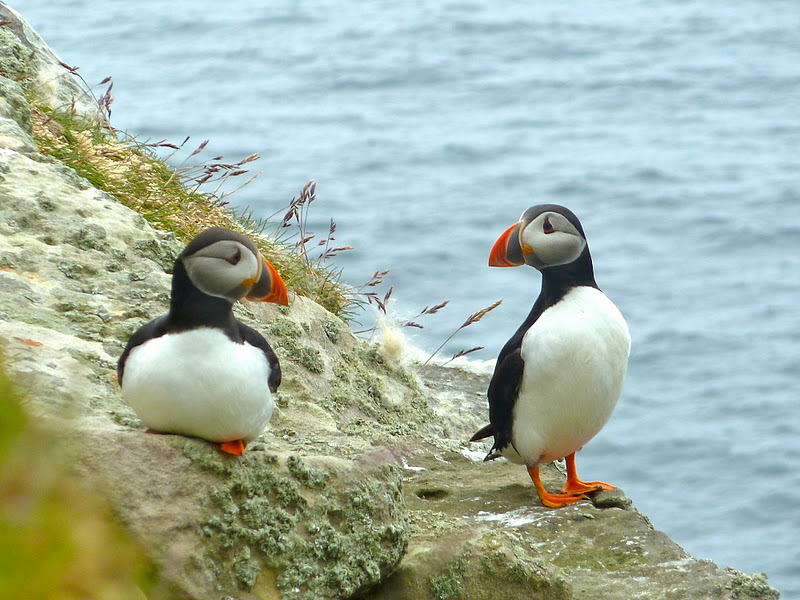
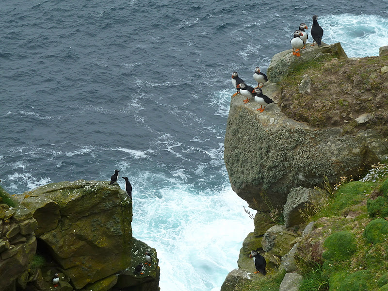
It was an easy descent down to Da West Bank where a number of Shetland ponies were grazing above the cliffs. It looked like a harsh environment for ponies but it wasn't exactly the pits. A group of bedraggled sheep were grazing, they had not been sheared in recent years and looked and behaved like feral animals. I descended to the cliffs where hundreds of puffins were nesting and quite happy for me to get close for photographs and to observe their quaint movements. I spent 15 minutes or so enthralled by being able to observe the life of puffins. And then down to Da Sneck o da Smaalie, a deep canyon formed from a fault in the sandstone, which was host to hundreds of Puffins and Razorbills. I climbed down into the canyon but not all the way to sea level: time was tight, there were some exposed and slippy rock faces and I was alone. 

I returned up the canyon and spotted some Shetland wren and wheatears before beginning the long climb up to Da Sneug. There was a faint path to the east of the cliffs but as I entered the clouds I had to take a compass bearing for the summit as I headed up the steep grassy slopes. The bonxies were not easily visible but emerged from the cloud heading towards me at speed and clipped my fence post a couple of times. When I reached the summit I stopped for lunch, unfortunately, I had not brought a drink, assuming that a bottle of water would not be allowed on the aircraft. 

I was determined to visit the highest cliff in Britain at Da Kame and set the compass for the kilometer-long trek across to the cliff edge. It was the most disturbing part of the walk, this was in Arctic Skua territory and they really get up close and personal. Despite the fence post, they clipped my shoulder several times as I worked my way across the complex terrain in the cloud. As I approached the cliff edge I inched my way down the greasy grass slope in the full knowledge that there was a 346m cliff imminent and visibility was no more than 15 metres. It was an anticlimax although I could hear the crashing of the sea below and the calls of the thousands of birds. I decided that instead of returning to Da Sneug I would continue to circumnavigate the island. I had the option of either keeping close to the cliff edge or bearing off inland to the east until I emerged from the cloud. Common sense took hold so I headed inland where I entered another nesting site of more bonxies; they swarmed me like giant midges. This place made Hitchcock's 'Birds' seem like a gentle adventure with nature. 

As I left the cloud above Da Clay Pool I could see the coastline ahead and I walked over to Summons Head. Unfortunately, this too was Arctic Skua territory and they are even more disturbing when you see them flying straight at you at head height. I put my hood up and my head down until I reached the start of Blober's burn, which provided an obvious route down to the houses at North Harrier. From here there is a single track that leads back to Da Toon alongside Da Crookit Burn. I was strafed on a couple of occasions by the bonxies but it was otherwise the most relaxing part of the day.

Da Toon o Ham is the main settlement. It is an untidy collection of dwellings, mainly derelict, in contrast to the impressive but probably over-designed new primary school with its bank of solar panels. The island is also served by a small hydro scheme and some wind turbines, which underlines the green credentials of the island. A pity that the same energy has not been applied to clearing the abandoned vehicles and machinery that litter Da Toon. The walk back to the airstrip allowed me to visit the church where a couple from Manchester who had been on the plane had also arrived.

We walked back to the self-service air terminal. It is a functional building, a large garden shed, that was ahead of the curve in its minimalism. It is a passenger's dream: a total absence of retail facilities, no check-in desk, and free tap water. The locals turned up for the afternoon flight: a teenage girl driving the fire appliance, a four-year-old on a quad bike and Willie extolling the virtues of island life, although coming from the West of Scotland, he did miss a drink. A tall distinguished gent asked me where I had been. I explained and he told me that there were 7000 bonxies on Foula. I think I had been buzzed by most of them and only the chicks seemed afraid of me.

I had heard numerous stories about the relaxed way of life in Foula. No flights arrived before 10:00 a.m. because no one would be up. A taxi driver had told me of a visit by a friend who had stopped to talk to the wife of the distinguished-looking gent. It was summer and she was tarring the roof - not exactly easy work for an elderly lady. He asked after her husband and was told he was on holiday. On asking where had he gone, he was told "Oh he's inside watching television."

Marshall, the friendly pilot, landed the afternoon plane and we chatted with him about our adventures as we took our seats. We were airborne in less than five minutes. I have not enjoyed flying so much since my first flight with Dan Air in 1970. And Foula, well just go there it is one of life's genuine adventures but get yourself a big stick, it is not for the faint-hearted.

Sunday, 5 June 2011

Muckle Roe: Ward Hill and the Hams


Mid-Ward Looking north


Looking North from South Ward

Sullom Voe from South Ward Hill

Mill Loch and North Ham

North Ham 
North Ham

Jeff at North Ham 

Ruins

South Ham

Peerie Jeff at Burg Ruin

Looking across South Ham

Geo

Papa Stour

Below Lighthouse

Burki Skerries

I had been hoping this would be a given day for the walk around the Muckle Roe coast and it was. My companion had lived here all his life and knew the complete history of Muckle Roe which had been passed down orally through the generations.  We started just after noon by climbing the new road to the cemetery which would have been a credit to the Romans had they got this far.  And then an ascent through the heather to South Ward with its trig point.  The views were good in all directions including the short walk across to Mid Ward which is the higher hill according to the Ordnance Survey although my altimeter did not agree with them.

The descent to Mill Loch could have been anywhere in Scotland apart from the sea sparkling in the distance.  This place was special and a rare treat and this was confirmed when my friend, who can identify and name any hill in Scotland, was thwarted by the photos I sent - to be fair he has never been to Shetland.

North Ham was reached, a resplendent cove on a tranquil day - a few seals flipped into the water and we began the long but spectacular walk back along the coast. There were geos, cliffs, ruins, beaches, views to Papa Stour and, from the modern lighthouse, we could see the guns that had been rescued and installed on Vementry to defend the entry of Swarbacks Minn from the German navy. The beach at Burki Skerries looked tempting at the end of a walk on the wild side.  There was a way to climb down at the far end for a bathe but a table at Frankie's had been booked with the Wood family and the lure of Blue mussels and chips was too enticing.