Showing posts with label Wainrights. Show all posts

Monday, 30 June 2025

Easing back to the hills

Tarn Crag above Easedale Tarn

Monday, 30 June 202

Ascent:         560 metres
Distance:      12 kilometres
Time:            4 hours 20 minutes

Tarn Crag     549m        1 hr 56mins  
 

I had survived yesterday's 10-kilometre walk, which included 400 metres of ascent, on a route to Little Langdale and back, featuring an additional climb over Yew Tree Crag to the quarry. It was my longest walk since February, and apart from a strained groin caused by a foolish attempt to run last week, I felt ok, tired, yes, but that produced a good night's sleep. 

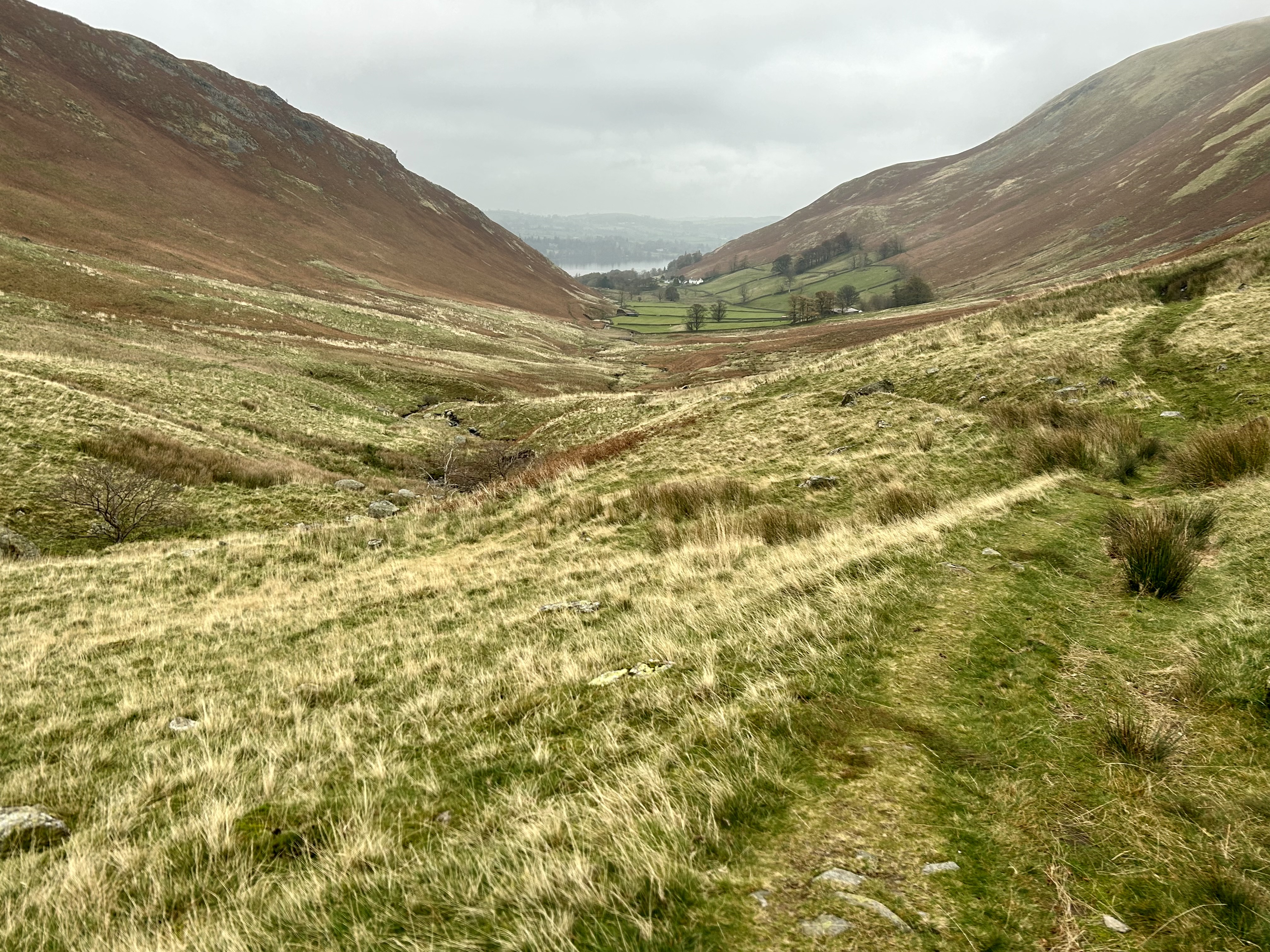
It was time to climb a hill, Gregor and Emily gave me a lift after lunch to Goody Bridge in Grasmere, from where I followed the Far Easedale path on a clear day with grey skies and high humidity. My objective was Tarn Crag, the only Wainwright Hill that I have still to climb in the nearby fells on this round of Wainwrights. The path is part of the Coast to Coast route, and there was a fair number of walkers heading eastwards. I stopped to talk to a woman who was on her fourth day and intended to finish phase 1 of her walk at Grasmere. She had just spent a night in Barrow House Youth Hostel, her first ever visit to a youth hostel. She was full of praise for the 'youth' hostel and the like-minded people she had met there, another convert. I wished her well and continued up to the new wooden bridge over the Ghyll at Stythwaite Steps. A steep path forks off to the left and eventually leads to a narrow path that climbs steeply as it winds through the bracken towards Tarn Crag. After climbing for about 15 minutes and emerging from the bracken, I stopped for a drink and a late lunch, perched on a large rock overlooking Easedale Tarn, sparkling in the hazy sunshine. I needed the break; my legs were fine, but my groin injury was not helped by the big vertical stretches.

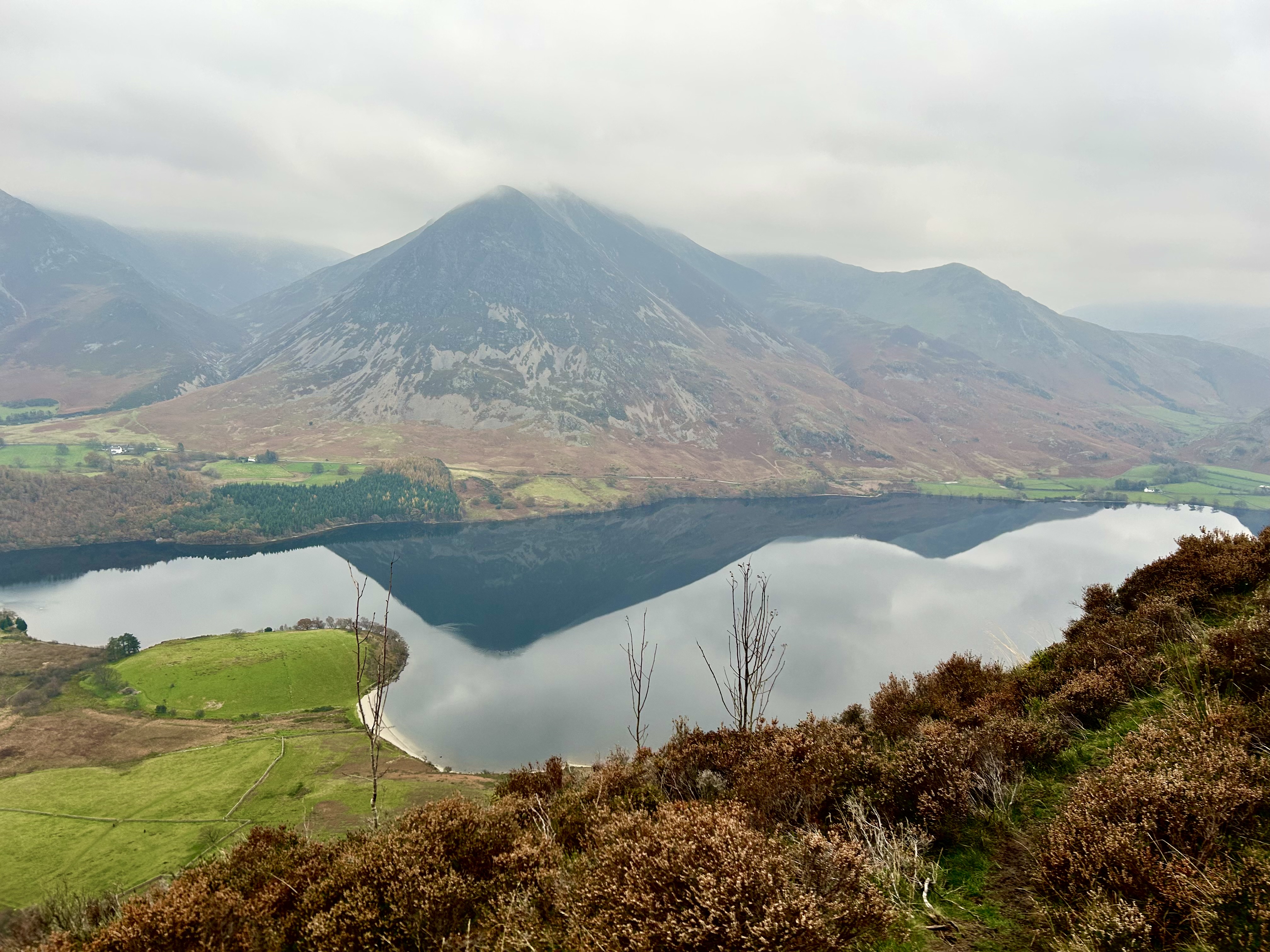
There was another half hour of climbing required as I edged upwards at a more sedate pace, coupled with occasional stops for chats with walkers descending. I had made it in less than 2 hours, which, in the circumstances, was fine. I took a rest before deciding to take a longer route back via Coledale Tarn, Eagle Crag and Easedale Tarn. Two older men who had been wild swimming in Coledale Tarn and drying themselves as I passed. They were cousins from Durham and Nottingham and had recently taken to wild swimming. When I asked them if they were trying to collect all the Lakeland Tarns, they were a bit flummoxed and said they hadn't thought of that, but it could make a good book. I told them it had already been done and could be found in any Lakeland bookshop. When they heard where I was from, they revealed that their grandparents came from Plean, and they had a cousin living there, and did I know him? It was time to move on. 

I headed to Eagle Crag and found the path down to Easedale Tarn. There is a steep rock section that was wet, slippery and slow going before the final kilometre to Easedale Tarn. I was uncharacteristically cautious, it reminded me of helping my mother down similar conditions on Snowdon (Yr Wyddfa) when she had offered to accompany me, I was 14 at the time. 

I have not been to Easedale Tarn since we had dragged the children up on an equally grey day, and despite its popularity, I have yet to discover the undoubted charms of Easedale Tarn, although the view across to Tarn Crag was impressive. I crossed the Sourmilk Gill on leaving the Tarn to begin the path down, not discovering until well down that it was the path back to Far Easedale Ghyll. It would add an extra kilometre or so, but I would still be 30 minutes ahead of my pick-up time of 6:15 pm. My limp was getting worse, but once on the better-graded path, I discovered that walking faster helped. 

I made it back to Grasmere by 5:45 pm; my lift was already waiting. We returned to Langdale and I rewarded myself with a shower, a beer, Wimbledon, and a lazy evening. I was delighted to have managed 12 kilometres, my legs felt good, but my groin strain was not happy. A rest day tomorrow.

Ascent by Far Easedale Ghyll

Easedale Tarn from the ascent of Tarn Crag
Coledale Tarn and Langdale Pikes from Tarn Crag


Descent down Eagle Crag to Easedale Tarn


Saturday, 15 February 2025

Grange Fell, Borrowdale


Watendlath Tarn

Thursday, 13 February 2025

Ascent:          345 metres
Distance:       6 kilometres
Time:            2 hours 2 minutes

Grange Fell        415m              33mins
Great Crag         436m.      1 hr 29muns

The last day of our three-day visit to the Lakes. It had been a success even though we had not ventured into the higher fells. The weather prospects were better today, and the idea had been to climb Skiddaw and its nearby peaks, but I had to be home at 6pm, so time was tight. The alternative was to continue to pick off some nearby lower hills and save Skiddaw for later in the year when conditions might be better. 

John had decided to give the day a miss and left after breakfast. I thought we should nip down to Watendlath to climb Grange Fell and then maybe a couple of hills on the way home. It was still early when we arrived at the empty National Trust car park at Watendlath. It had been a regular visit when the family were younger. The children would paddle in the tarn, we would wander up Grange Fell chanting Jopplety Jopplety How, the name for the collection of outcrops on Grange Fell, and return to Watendlath for an afternoon tea of rum butter scones and ice cream for the children.

The tea room was closed for winter, and today, after a preamble around Watendlath and its tarn, we made a quick ascent to the Grange or Brundle Fell. We passed Jopplety How, which looked to be an enticing place for children to play, but we just visited the nearby summit. Keith suggested that we could take in Great Crag, another Wainwright to the north. I had previously climbed Great Crag from Stonethwaite, but it looked a logical extension to a short walk so we cantered over. The path was slightly boggy until the rocky staircase to the fine twin summits of Great Crag. There were good views of the snow-capped summits of Skiddaw and the Helvellyn Range was peeping above the long High Seat to High Tove Ridge. Scafell and its outliers to the south were blanketed in clouds. It was only 10:30am, and the descent to Watendlath was just a couple of kilometres. We decided to call it a day and go for a morning coffee and then head back north.

We called in at the Rheged Centre near Penrith, a grass-covered building, visitor centre, gallery and cinema of historical importance. I last visited it with the family on our way to a fortnight's holiday in Cornwall, and I was pleasantly surprised at the range of activities and events on offer. After a coffee, scone and wandering around, we headed back to Glasgow, where I dropped Keith and made it home by 4:30pm. Another 8 of the lower Wainwrights had been climbed, and we had experienced some surprisingly good visits to other places of interest. After 35 years of focusing entirely on trying to climb as many hills as possible in a day, I am beginning to get the hang of not spending all the time on hillwalking trips on the hills.

Skiddaw from Grange Fell

Watendlath from Great Crag

Helvellyn Range from Great Crag

Skiddaw from Great Crag


Friday, 14 February 2025

Pensioner's Triple Lock of Wainwrights


Skiddaw in the cloud from Latrigg
Wednesday, 12 February 2025

Ascent: 870 metres
Distance: 15 kilometres
Time: 4 hours 37 minutes

Latrigg             367m          22mins              37mins
Dodd               491m    1hr   2mins       1hr  40mins
Castle Crag     300m    1hr 10mins       2hrs 22mins

The intention had been to climb Skiddaw and the 5 surrounding peaks, but they were hidden in the clouds, and a strong easterly wind and sub-zero temperatures made us think again. Perhaps I could collect a few of the singleton Wainwright fells instead. There were no objections from Keith and John. As pensioners, we had had our fill of winter days like this in the Scottish mountains. There was no need to repeat the misery since I was no longer eligible for the winter fuel allowance, but we all benefited from the triple lock.

Latrigg was just a 3-mile drive away, and we parked in the empty Skiddaw car park beyond Underscar. We followed a track for wheelchairs to the summit, passing the viewpoint over Keswick and Derwentwater, which were smothered in a lighter shade of grey. We found a small stone at the summit, engraved as such, but easily portable if anyone wanted to change the grid reference of this low, flat but worthy Wainwright. We skipped down to the car by a direct route, not exactly a Fandango. 

It was still not time for a morning coffee, so we headed 3 or 4 miles up the shores of Bassenthwaite and parked at the Forestry Commission, which now charges 50p for every 15 minutes and then provides a map that is badly drawn and misleads users along the numerous forest trails as they twist their way to the summit. I was wrestling with a cold and found the ascent on the steep paths tougher than usual. The conifer plantations kept the cold north-easterly winds at bay until we reached the fine summit. The views were a palette of greys and greens that merged in the distance. It was still morning as we completed the circuit. I suggested Castle Crag in Borrowdale as the next hill. 

We drove down Borrowdale, past the old Barrow House Youth Hostel and the opulent but intrusive Lodore Falls Hotel and into the jaws of Borrowdale with its intrinsic charm relatively untainted by the commercialism of the revamped Lodore Falls Hotel. We parked before Grange in Borrowdale and walked across the double bridge to the village. We had stayed here in a cottage with three children under three, the girls paddled in the river every day, and we had climbed Castle Crag. It is an exquisite 2-kilometre walk from the village, past a fine campsite and along the river. The final section is on an ever-increasing gradient before a final switchback and steep climb through Scots Pine trees, scree and a quarry to the summit. I know not how we ever managed to get the three children with Aileen carrying Gregor, a two-month-old, to his first summit.

There were good views towards Rossthwaite and the high fells leading to Scafell Pike. The cloud level and snow line were intermingled. We explored the quarry before returning to the car, very happy with the three walks we had made on a day that could have been no fun had we stayed in or attempted Skiddaw. We still had time to visit the outdoor shops in Keswick before returning to the Keswick Hostel. 

After our evening self-catered meal, I started a conversation in the lounge with three cyclists, probably in their early seventies but clearly still formidably active. They were former professional cyclist from Lancashire and Yorkshire; one had won the Tour of Britain, and two had ridden the Tour de France. They all had palmares that were a testimony to their northern roots. Youth Hostels are full of legends.

Keswick from Latrigg

On Dodd

Ascent of Castle Crag

Rosthwaite from Castle Crag

Castle Crag quarry

Thursday, 13 February 2025

The Ennerdale Three


Grike Summit

Tuesday, 11 February 2025

w     Grike                488m             50min          
w     Crag Fell.         523m      1hr  18mins
b      Whoap.             511m
w     Lankrigg Fell.  541m.     2hrs 36mins

Our winter few days in the Lakes promised low cloud, below-freezing temperatures on the fells and stiff easterly winds. I collected Keith from Glasgow during the morning rush hour, adding an extra 20 minutes to the journey. We still made Ennerdale Bridge by 11:30 am. John. arrived from Selkirk 20 minutes later. The three low hills to the west of Ennerdale were the most remote hills left on my Wainwright round and the most westerly and therefore the most likely to be cloud-free. They would allow Keith to collect an additional 6 Birketts. Birketts are the 541 peaks over 1000 feet in the Lake District National Park. 

The forecast proved true, our hills were cloud-free, but to the east, almost all the fells had their heads in the clouds. We parked at Scally Moss on a road over the moor that acted as a rat run for traffic to the Nuclear Power Station at Sellafield. It was after 12 noon before we started walking, and there was a bridleway heading towards Grike. Keith took a less direct route to collect the Birkett of Blakeley Raise on the way. We met some environmentalists testing soil samples for Natural England and arrived at the summit of Grike to some shafts of sunshine and a white bank of clouds to the east.

It was an easy trot over to Crag Fell where we had some food and peered down on Ennerdale Water before the cold wind prompted the next leg over to Lankrigg Fell via a dog leg over the curiously named Whoap, an intermediate Hill and Birkett. Despite it being February, the ground was not too boggy. The final climb to Lank Rigg was the only steep climb of the day, just as well because I was well short of hill fitness after little exercise in the grey wet days of recent weeks. We were served some wonderful light conditions on the summit of Lank Rigg, although it was difficult to see Sellafield.

John and I took a direct descent from Lank Rigg towards the River Calder but had some difficulty finding a crossing point and had to walk back to a Ford before the final kilometre towards the road. Keith, meanwhile, had shot off to climb three more Birketts and still arrived at the car ahead of us. It was 4:30pm, Sellafield was out, and a caravan of Teslas and vans were racing back along the rat run.

It was almost 6pm by the time we signed into Keswick Youth Hostel. We decided to eat out and found a Wetherspoons brimming with customers and providing a surprisingly good meal with a pint of beer thrown in. I have not previously been impressed by Wetherspoon pubs, but this was a well-run establishment that had captured a significant clientele amongst young and old alike. It had been a far better day than we had expected, but the forecast for the next day was dire.

The trot across to Crag Fell

Whoap and Lankrigg Fell from Crag Fell

Ennerdale Water from Crag Fell

Lankrigg Fell and afternoon shadows

On Lankrigg Fell

Sellafield glows in the distance

Thursday, 7 November 2024

Loadpot and Wether Hills

Wether Hill summit

Tuesday, 5 November 2024

Ascent:       624 metres
Distance:    12 kilometres
Time:          3 hours 9 minutes

Wether Hill     675m    1hr 13mins
Loadpot Hill   672m    1hr 40mins

On our final day of the November fog fest, we decided to clear some Wainwright hills east of Ullswater, I had two to climb and Keith had four. We dumped John's car at the car park east of Pooley Bridge where the High Street ridge emerges and I drove us up to Howtown where I found a parking space after the cattle grid half a kilometre beyond the hotel. We walked up to the hotel and followed a concrete track alongside Fusedale Beck, Steel Knotts to our right, Bonscale Pike to our left and our objectives for today lost in the low clouds ahead.

Beyond Cote Farm, the track gives way to a path that climbs steadily initially. Hundreds of birds took off from some rowan trees along the beck and swarmed in what would have been a murmuration had they been Starlings. My Merlin app on bird sounds confirmed that they were smaller and skittish Redwings. The incline of the grassy path increased and we entered the clouds as we reached 500 metres and began the final ascent to the ridge a few hundred metres south of the undistinguished Wether Hill. There were not even sufficient stones to rebuild a small cairn.  It was colder on the summit ridge and we began the simple trot across to Loadpot Hill which boasted a trig point and little else. We ate some food whilst waiting for Keith to search for the true summit on the plateau that serves as the high point. John and Keith continued to Bonscale Pike and Arthur's Pike whilst I returned to find the path back to Fusedale.

The descent was quicker than I had expected, after emerging from the cloud there were reasonable views of Steel Knotts and Beda Fell, which I had hoped to climb but I had assumed Keith and John would be back at his car about the same time as I would arrive in Pooley Bridge. I dawdled through Howtown recalling the beautiful summer's day when we had lunched there with Aileen after she had dropped us at the Kirkstone Pass so that Gregor and I could run the High Street ridge. My Merlin app identified both Fieldfare and Redwing above the woodland. The journey to Pooley Bridge was held up by a flock of sheep but I was still there before 2pm, an hour and a quarter before the others arrived. I could have climbed Beda Fell. 

I drove Keith back to Glasgow, pleased that I had finally fitted an adapter and holder for my phone that could be used as a satnav device in the car. I was home by 6pm, the golden hour, but I could hardly see a thing in the mix of fog and nightfall. November high pressures may keep the wind at bay and temperatures reasonable but they make you realise that visibility is the most important condition for hill walking.

Path up Fusedale

Pensioner's day on the fells

Loadpot Hill

Steel Fell and Beda Fell on descent

Fusedale

Howtown Hotel

Traffic calming


Wednesday, 6 November 2024

Mellbreak and Hen Comb

Mellbreak

Monday, 4 November 2024

Ascent:       789 metres
Distance:    13 kilometres
Time:          4 hours 21 minutes

Mellbreak North Top   509m    1hr 14mins
Mellbreak                     514m    1hr 38mins
Scale Knott                   338m    1hr  57mins   
Hen Comb                    506m     3hrs 09mins
Little Dodd                   362m    
3hrs 27mins

It was day 2 of the November fog fest, we decided to visit Loweswater and climb the two steep peaks that Keith and I had yet to climb on our second Wainwright Round. It was mild with no wind but the fells were smothered in cloud. We parked by the Kirkstile Inn and wended our way up a splendid track leading to Mellbreak, the impressive pyramid of a hill that overlooks Crummock Water. 

There is an easy option to head along Mosedale and climb by a path to the col between the twin peaks. We took the steeper route up a path through the scree and rocks on the north face. Time was on our side so there was no pressure and despite the poor visibility the day had an autumnal calmness that was surprisingly enjoyable. We crossed to the higher southern summit before descending to Scale Knott, a Birkett, a hill of over 1000 feet in the Lake District. Keith collects hills of all denominations and we were accomplices although it was hardly difficult, a mere 200 metres away from the path with a minimal ascent and some Herdwick sheep posing on the summit.

We dropped down to the wetland between Mellbreak and Hen Comb where we had almost 2 kilometres of boggy ground to cover to reach the path up Hen Comb. John and Keith took a more direct route to the summit whilst I battered through the boggy ground to reach the path that gave a steep but reasonable route. We emerged on a summit and took some time for food and drink before an easy descent to Little Dodd, the Birkett at the northern end of Hen Comb. 

There is a good path down to Mosedale where we crossed the beck and found the excellent track back to Kirkgate Farm and the Kirkstile Inn. We took some time to look around the large churchyard, builders were working on replacing the roof slates. It was still early and we had thought about another couple of hills but returned to Keswick and spent an hour in the outdoor shops before calling in for a fish supper. 

We returned to the Youth Hostel and spent much of the evening talking to other guests including a couple of Glaswegians whom I found much in common with.
Track to Mellbreak

Whiteless Pike over Crummock Water

Scale Knott above Crummock Water and Buttermere

On Hen Comb

Mellbreak north top

Whiteside and Grasmoor

Lakeland Barn


Haweswater Wainwrights

Branstree: Artle Crag Cairn...timber!
Sunday, November 3 2024

Ascent:       963 metres
Distance:    17 kilometres
Time:          5 hours 32 minutes

Tarn Crag                  664m      1hr 43mins
Gray Crag:                638m      2hrs  9mins
Branstree NE Top     673m     3hrs 38mins
Selside Pike              655m      3hrs 56mins
Branstree                  713m      4hrs 34mins

I started early to collect Keith from Glasgow and headed for the Lakes for three days of walking. We made it to Haweswater by 11:30am after a slow 20 miles on the narrow single-track roads beyond Penrith. We jiggled our way through the remote and tranquil Lakeland villages of Askham, Butterwick and Bampton and the bucolic scenery of Mardale. It was my first visit to this remote part of the Lakes, although I had always intended to visit Mardale after browsing photo books of the Lake District as a child. The villages, hotels and houses looked unchanged from the 1950s. Haweswater was flooded in 1935 by Manchester Corporation to provide a water supply for Lancashire, and it has a rugged, wild appearance compared to the more tamed lakes elsewhere in the National Park. 

The long single track to the road end of Haweswater brought us to a crowded car park. We struggled to find a place amidst the Land Rovers and other vehicles that had gathered for the last open day for trail bikes and Land Rovers to have permission to test their driving skills on the Gatesgarth Pass that climbs to 582 metres as it snakes its way to Longsleddale. John had already arrived, and it was almost noon as we began the long ascent up the rocky path chiselled over the Gatesgarth Pass. 

I had previously climbed these hills from Longsleddale and knew that they were amongst the boggiest hills in the Lakes. I had warned John and Keith, and I wasn't wrong. We decided to paddle out to Tarn Crag and Grey Crag first and savour the higher drier hills of Braintree and Selside Pike later, when we hoped the hill fog might have lifted. Our optimism was unbridled. Keith took us on a shortcut from the top of the pass to the col between Braintree and Tarn Crag. The path might have been quicker and certainly easier but hill walking is not about making things easy, it is a gymnasium for nature's freeloaders.

The ascent of Tarn Crag was a walk up a slow-moving horizontal waterfall over grassland. The flat and undistinguished summit of Tarn Crag is embellished by a tall surveying pillar built by Manchester Corporation when constructing the Haweswater Dam. We continued across to Grey Crag and met a couple of other walkers; the conversation turned to the vast number of hill classification schemes that had sprung up in recent years. Keith had disappeared to bag a nearby Burkett, or was it a Nuttall, but probably not a Marilyn or a Hewitt, or was that the other way round? The confusion stems from the three factors that determine hill lists. Are they random or rule-based classifications? Do they use imperial or metric measurements? What is the height drop between adjacent possible summits? All the classifications provide some excitement for the tick-box fraternity. 

We had some food and drink before beginning the long up hill and down dale squish to Branstree. Well, not quite, we traversed across to Selside Pike once we reached a suitable height and took in the North East Top of Branstree. It is higher and much closer to Selside Pike than Brantree, but Wainwright had adopted a random classification system that was imperial but took no account of the height difference between whatever he sketched in his list. He was a Hill list anarchist, but what do you expect from someone from Blackburn?

The last leg was the trek back to Branstree with its two cone-shaped cairns, but the true summit, a couple of hundred metres away and is a stone ring in the ground that presumably once held a trig point. There were no rocks in the vicinity to erect a cairn, so we began the quick descent to the Gatesgarth Pass as the November light combined with the hill fog made for an eerie descent on the rocky path back to Haweswater. It was one of those occasions when sodden shoes and socks made changing footwear and socks essential before the drive to Keswick. 

There had been a diesel spillage on the A66 and a diversion, so it was well after 6pm before we were able to enjoy the splendid facilities of the Keswick Youth Hostel. A hot shower, a well-equipped kitchen, a bar and helpful staff make it a near-perfect base.  Youth hostellers nowadays are not Generation Z or even Millennials; we are mainly the generation called baby boomers, but I prefer to stick with Youth as a descriptor, it has the promise of more exciting times ahead. 

Bog trotting in Mosedale towards Tarn Crag

Surveying Pillar on Tarn Crag

Selside Pike


Saturday, 26 October 2024

Place Fell, Lakes

Place Fell
Friday, 25 October, 2024

Ascent:         538 metres
Distance:      7 kilometres
Time:            1 hour 46 minutes

Place Fell        657m     58mins

After three days of visiting my childhood territories and spending time with my sister and brother, I headed home. I have always found it hard not to visit the Lake District on the journey between Lancashire and Scotland. I had suffered a back spasm the previous week and had not exercised for a week apart from a fast promenade along the Lytham waterfront yesterday. I scanned the map for a hill that would not be too taxing. Place Fell is an impressive hill overlooking Ullswater and the hamlet of Rooking. I had yet to climb it on the latest Wainwright round. It looked a perfect fit, although driving up the M6 in the grey clouds made me doubtful. I had not climbed Place Fell since the Karrimor (OMM) International Mountain Marathon in 1992, it was towards the end of a long day and I don't recall much about it.

Despite being in the game of buying a bike, I gave the enticing cycle shop in Stavely a miss and drove through Troutbeck and down the Kirkstone Pass to Patterdale where I found a large parking area managed by the hotel. It was noon as I began the walk on a mild autumn day, Place Fell was circled by a halo of blue skies although Helvellyn and the hills to the south were enveloped in clouds that seemed to be heading north towards me. I set myself a steady pace on the road to Rooking passing a family of three and a woman escorting her elderly mother on the steep path that starts from Rooking and is signposted to Boredale Hause and Angle Tarn. 

The path climbs steadily with stone steps through the bracken. It gives good views back to Ullswater and the Helvellyn range and a direct view to the sombre-looking Brothers Water and Kirkstone Pass. There was no back pain and apart from a couple of photo halts, no pace dropping, and I was at Boredale Hause within 30 minutes. Two girls of about twenty were on their descent from Angletarn Pikes and encouraged me to go there but I had climbed them a couple of months ago so I hooked to the left to start the steep climb to Place Fell. It is a good path with a 260-metre ascent to be made, a steeper section below Round How and then a half kilometre across a flattish ridge to the rocky summit of Place Fell. The guidebook had said 1 hour 35 minutes for the ascent but I was up in less than the hour. 

I had entered the clouds at about 500 metres and stopped to put on a jacket. I was hoping the clouds would disperse and they did for a fleeting few seconds just after I reached the beautifully constructed trig point that sits erect on a rocky plinth. I ate an orange and drank some water hoping that the clouds would break but no luck today, it was retribution for all the sun-kissed days of September.

I began the descent and bumped into three men nearing the summit, I had passed them on the way up. They asked where I was from and on telling them Scotland they said I didn't sound as if I did. They were from Preston and I discovered that the father of one of them had been brought up on the same estate as myself. The coincidence continued when he told me he had bought a £3000 bike at the Ribble Bike shop in Clitheroe the day before. I had been there two days ago but had yet to decide whether to buy the bike I had been measured for,  it certainly wouldn't be as pricey as his. Another five minutes further on the descent I met a family from Stockport whom I had passed on the track to Rooking. They wanted a break from the climb and regaled me with their recent trip to Scotland with stops on Skye and Stirling. They had been mesmerised and intended to go again next year. I recommended some places for their next trip before I finally extricated myself and began to run down the path to catch up on time. 

As I emerged from the cloud below Round How another couple appeared, I had spoken to the man earlier as he was struggling to get the car park payment machine to work. He was a farmer from Hexham and on hearing I was from Stirling told me his family had originated from Stirling. His wife prolonged the conversation as we discussed the felled sycamore tree on Hadrian's wall, Alnmouth, Armstrong's Cragside House and climbing the Wainwright's. This was the fifth Wainwright they were climbing and they had recently made it a mission to climb them all. They were surprised that I had climbed them all and began to ask questions. I showed them a route down Place Fell to the north and encouraged them to take this and walk Wainwright's favourite path alongside the shores of Ullswater back to Rooking. The conversation was endless and I half expected to be invited for a weekend in Hexham. Place Fell was shedding its cloud cover so I encouraged them to see it in all its glory so that I could escape. 

I had lost 35 minutes to these enjoyable conversations during the descent so I ran most of the way down to Rooking where I paused to take a photo of a glorious Lakeland house decorated with a couple of pumpkins. It was almost 3pm, I changed my shoes and began the journey home. I was delighted to tune in to a 5 Live discussion with Helen Lewis and Armando Iannucci, both wonderful raconteurs, on the meaning or non-meaning of political words and phrases. I reached Hamilton before five and stopped to buy some provisions when the car computer told me to take a rest. The rain and darkness had fallen by the time I continued. Another interesting day had been hewn out of what could have been a tedious journey home. 

Path to Boredale Hause, looking back to Patterdale

Helvellyn view

The final romp to Pace Fell

Perfectly built Trig Point

On the descent

Looking to Boredale Hause from Rooking

Rooking Lakeland House