Wednesday 23 March 2011

Gael Charn (Monadhliath)

Gael Charn: the approach

Wednesday, 23 March 2011

Ascent:       640 metres,  
Distance:    13 kilometres, 
Time:          3 hours 49 minutes

m   Gael Charn (Laggan)   926m    2hrs 12mins

Travelling back by plane from Shetland to Inverness this morning, I had a yearning to get another Munro in the bag.  The day was not encouraging with claggy conditions and the cloud down to about 500 metres.  However, any excuse to get off the A9 is to be seized so I turned off at Kingussie to avoid the road works ahead and took the road to Newtonmore and then Laggan.  Gael Charn is the most westerly of the 4 munros in the Monadhliath Mountains the vast stretch of unexceptional high land to the north-west of Newtonmore.  I had combined the 4 Munros on two occasions, once from east to west as a long hill run in summer and once from west to east in December in deep snow.  We finished at 7pm, long after dark, and my two friends regarded this as one of the dafter expeditions that I had dragged them along on.

I had also climbed Gael Charn twice as a singleton and that was the plan today.  I drove to Garva bridge - one of the most remote places in Scotland and source of the River Spey.  It was 11:30am before I started walking, light rain and low cloud meant there was little to see on much of the ascent.  I crossed the river to the track and then crossed back again and followed an old path which kept to the right bank of the Allt Coire nan Dearcag.  

About halfway up I met a young Cornishman descending and we had a long chat.  He worked for IBM in Portsmouth but he had moved to Doune near Stirling mainly so that he could climb the Munros.  He had a weekly commute to Southampton but seemed to think it was a worthwhile trade-off.  He had all the enthusiasm of someone newly converted and had managed 86 in a year and a half with most of the best ones yet to do. I was a bit envious of the new adventures in store for him but delighted that he was getting so much enjoyment out of walking the Munros.

The ground was waterlogged apart from the fingers of wet snow that extended don the hill and became predominant above 600 metres.  The burns were swollen so I had to head towards Beinn Sgiath before I found a place to cross the burn and make the last 250 metres of ascent. It seemed a long way to the summit cairn but I was encouraged by the sound and then the sight of three ptarmigan and, unusually, I got close enough to photograph them before they flew off.  

A drink was all I had with me but I spent ten minutes at the summit listening to the ptarmigan in the vicinity.  It was still cloudy and I had to take a bearing at the start of the descent, I saw another four ptarmigan and a couple of mountain hares in their white winter coats. The cloud eventually lifted and the route down became obvious.  The day was still improving, I made good speed and enjoyed the views over to the Creag Meaghaidh range of hills and managed to get some photographs on the descent.   

The pylons march across the upper Spey valley from the Corrieyairack Pass but are lost in the grandeur of the highland landscape. Larger pylons are to be erected as part of the Beauly to Denny powerline upgrade but there will be fewer of them and I doubt that they will be any more detrimental to the landscape. This is a remote and unfrequented country and not one of the most sensitive parts of the route, although some would dispute this. The walk had been a pleasant interlude which I had not anticipated at the start of the day but 'go with the flow' adventures are usually the best way to travel. 

I was changed and driving away by 3:25pm. It is a long way back to Laggan but then the A889 to Dalwhinnie is much preferable to the A9.  I was home by 5:30pm and fully appraised of the Chancellor Osborne's budget, which seemed pretty much a 'there she blows' holler. I doubt that it will do anything to ameliorate the damage that is currently taking place to the economy or the cost of living. 
Gael Charn Summit

Garva Bridge - the source of the River Spey


River Spey from Garva Bridge

Ptarmigan near the summit of Gael Charn


Sunday 20 March 2011

Saxa Vord and Valla Field

Saxa Vord, windy and ugly

It was another cool grey Saturday and the last chance to get in some walking in Shetland as I will be away from Shetland for the next few weeks. After nipping into town to buy the Yell and Unst OS map I picked up my walking companion, Ann, who runs the Shetland Trust and we headed for the northern isles. Not for the first time I marvelled at the quality of the ferry service across the Sound of Yell.  The immaculately maintained ferry had no roll across the choppy waters and, whilst having a cup of hot chocolate for 60p in the luxurious lounge, I took a call from my daughter in London. It was her birthday and we chatted for ten minutes as I watched the cormorants skimming the sound.   

We made a quick dash through Yell to reach the Unst ferry; the sea views to the north and east were captivating with some fine dwellings having been built to take advantage of the views. It was good to observe the new development and refurbishment of crofts taking place on this remote wild island.  The roads are near perfect and, as the car descended down to the ferry terminal at Gutcher, the ferry rolled in from Fetlar. I asked the crew if we could travel on the bridge and we were immediately made welcome. Most of the passengers are regulars and they spend the 10-minute journey in their cars.

The conversation with the experienced skipper and his crew was about the purpose of our trip, not many southers come this far north in winter. They were a bit surprised to find that we intended to climb some hills on Unst or that there were the two Marilyns - Saxa Vord and Valla Field. They knew the former, which is topped by an early warning radar station that previously had provided many jobs. They were unfamiliar with Valla Field and asked where it was - I pointed to a long ridge that seemed to be in the right sort of direction and, true enough, it turned out to be Valla Field. They were keen to hear of our exploits and suggested we catch the 16:05 ferry back otherwise there would have to be a detour on the next ferry via Fetlar that would add a couple of hours to the day. It meant only 4 hours was available for the two climbs and quite a bit of driving was involved as well.

Valla Field,  216metres, 8km of walking, 1 hour 32 minutes

Arriving on Unst, the newly restored Belmont House peered down on the pier as a reminder that the Lairds had been all-powerful here until the last century. A couple of miles up the road I turned left for Westing and parked just by Crosbister where the well-metalled road that was devoid of traffic had warning signs for ducks. I suspect that we may have been the first non-locals to travel this road for quite a while and on the day it was one of the few parts of Shetland with no birdlife.  It was time to start walking and the first kilometre involved a direct ascent over boggy land to reach the track at Bordi Knowe. Thereafter it was a simple walk with a steady climb up the track, watching a helicopter shuttle some containers of Salmon smolt from Baltasound. Saxa Vord appeared in the distance and eventually, the entire Valla Field ridge came into view.  The coastal areas to the west looked spectacular although it was not that clear and the strong winds were sapping the energy from our legs.  

The track up was better than many roads in the central belt of Scotland and had poles all the way up and even a crash barrier by one bend. The MoD must have built it during their time on Unst as there was also a disused quarry as well as some peat banks adjoining the track.  Below us, the Loch of Watlee looked like it might harbour some red-throated divers but it was several hundred feet below us.  The trig point at the summit was adjacent to the foundations for some old communications equipment. Time was tight so we made a fast march back into the stiff south-westerly wind and then through the boggy ground to reclaim the car, taking care not to take out any ducks on the return journey to the main road

Saxa Vord, 290m, 6km of walking, 1 hour 12 minutes

It is about a 20-minute drive to Norwick on the south-east flank of Saxa Vord. I parked at the sheep wash and immediately 3 shetland sheep took shelter under the front wing of the car licking the front tyre. We spent 15 minutes having a break with some crab bannocks and a drink. This was followed by that troubling moment when you fall out of a warm car into the wind and brawly inclement weather for your second walk of the day. There was only one way to go and that was straight up through the boggy ground until reaching a track by the Ward of Norwick.  And then we veered westwards to Sothers Field before heading north for the sinister-looking summit of Saxa Vord.

It may no longer be an early warning station but the keep-out signs and threat of the Official Secrets Act are still there and for once I decided not to tackle the high fences.  It felt alien and did not encourage anything other than a fast exit jogging most of the way back to the car.  Without any hesitation, I drove straight to the Wick of Skaw, the most northerly settlement in the UK and the location of a fine beach. We had another quick jog to the sea and back, there were only 25 minutes left to make the ferry.  It gave no time for a visit to the Valhalla microbrewery but allowed a couple of minutes for a close-up look at Belmont House before rolling onto the ferry.

The best parts of the day were yet to come. We were welcomed back onto the bridge and invited to take the wheel of the ferry crossing back from Belmont to Gutcher. The skipper of the Yell Ferry was also on board on his way to start the late shift. He invited us to join him on the bridge of the Yell ferry later. This gave us a chance to visit Ann's friend in Mid Yell for coffee and some wonderful brunnies (thick oatcakes). The kitchen was full of fine cooking, the smells of a dinner party to be held later that night, a pity that we couldn't have stayed.

We had lingered too long so there was another quick charge to the ferry at Toft where the skipper kept his promise and escorted us to the bridge. It was five flights of stairs to the bridge and nothing could have prepared you for the hi-tech electronic equipment that filled the sumptuous carpeted bridge. You expected an admiral to be in charge, not a friendly local guy who composed music and jingles for apps in his spare time.

Again the wheel was offered and Ann waltzed us across the sound unable to keep a straight course using a PlayStation-sized wheel. Watching the skipper make smooth docking manoeuvres with the electronic guidance equipment was described by Ann as "like buttering bannocks". He was greatly amused because it rang true and that used to be women's work. Every trip to the Isles is an adventure with courtesy, good humour and friendship the underlying currency of island life in the Northern Isles.

Nature's Infinity Pool on Valla Field looking to the west

Warning sign for Ducks on the Westing Expressway

Community-run bus shelter at Haroldswick


Unst's instinctive warmth and friendliness does not extend to the MoD

Ann, the most northerly citizen in the UK, at the Wick of Skaw

Superb ferries equipped with the latest technology - grown-up PlaySations


Saturday 19 March 2011

Up Helly Aa fae Brae


All torched out

Jarl and Children on da galley

Moon versus torches

Torch is upside down Peter

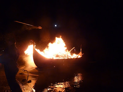
Torching the galley

Pyromaniacs all

Jarl Squad watch a year's work float off on fire

Bright side of the moon
Friday 18 March 2011

After a star-filled night, the cold bright air just lit up the town at dawn on Friday.  An early morning run around Lerwick was a compulsory start to the day. There are few better places to be at first light than on the Nab with views down the Sound and across to Bressay - light doesn't come any clearer than this. 

I bumped into an eminent recently retired Shetlander on her morning stroll and commented that it was sunny so it would probably be raining this evening for the Up HellyAa at Brae. Had it been raining it would have been dry in the evening. She replied that it depended on how fast was time but when it was windy it would usually get windier and when it snowed it would be all these things as well. All of which makes weather forecasting pointless in Shetland. So after this austerity government have abolished Coastguard Stations and the Emergency Tugs perhaps they should to take out the Met Office as well!

Unfortunately, when I grabbed my camera to capture the perfect morning the battery compartment was bare, I had left it on charge at home before returning to Shetland. It was the last of this year's Up Helly Aa's at Brae and a few folk had suggested that it was worth a visit and that required a camera. But a day's work first and I barely had time to nip down to town and buy a new battery for the camera. It cost £40 and this is symptomatic of a devious consumer goods pricing strategy that is becoming ever more prevalent. It is most wantonly exercised by manufacturers of printers who charge the same for a set of replacement inks as the purchase price of the printer. 

By 6:30pm the hail was ratatatting at the windows and I had abandoned any thoughts of heading north but slothness is an original sin so I persuaded myself to go out. It was not difficult when I realised that the alternative was red nose TV. I phoned a friend who had suggested it was worth going and she agreed to go along as well.  Arriving at Brae the rain had stopped and there was a ring of fire ahead.  We abandoned the car at the south end of the town and jogged past the queue of vehicles that were following the Up Helly Aa procession. The route curved around the voe from Frankie's fish and chip shop, the most northerly in Britain and one of the best, to the boating club.

About 500 souls had grown beards and/or wrapped themselves in a variety of uniforms from Vikings to Fairies to Roadworkers.  They all carried substantial torches made from hessian soaked in fuel and this was not easy in the gusty cold wind. The sparks were flying and burnt a number of small holes in my jacket as we overtook the squads and headed for the front of the procession. The galley was guarded by the Jarl Squad that included several colleagues who had been growing their beards since November. There were far more people in the procession than spectators but active participation is practised not preached in these parts.  There must have been a million candles of light emanating from the torches, even Rhod Gilbert would have been impressed.  The full moon was struggling to compete. 

The galley and the procession continued to the boat club where the galley was taken to the slipway.  It was launched on an unusually calm sea and floated out but held within throwing distance so all of the squads could throw their blazing torches onto the lovingly constructed galley.  With several hundred torches aboard and the galley a blazing inferno it was then pushed out into the voe. 

The Jarl thanked everyone for participating and the chilled participants and friends made for the Community halls for a day or so of partying at the hops. We had a 30-mile drive back to Lerwick but cold weather creates warm folk as I discovered when I was invited back for food and drinks with friends.

Saturday 5 March 2011

Ronas Hill and Da Lang Ayre

Ronas Hill Cairn
Looking across Ronas Voe
Descent to da Lang Ayre
Red Sand of da Lang Ayre
Red, White and Blue
Turls Head
The Cleiver
Da Lang Ayre and Gruna Stack
Foula in distance from White Grunafirth

Ronas Voe from White Grunafirth

I finally got round to climbing Ronas Hill, the highest hill in Shetland, something I had been contemplating since November. I had been waiting for some reasonable weather, which is not that frequent in a Shetland winter. Louise in the office had recommended that I visit Da Lang Ayre as well. It is a mile-long beach of red sand backed by 230m cliffs, it also involves a 10-kilometre metre walk from the nearest road including the ascent of Ronas Hill.  I asked around and most folks had heard of Da Lang Ayre but had never been there apart from Maurice, the Fetlar fiddler, who told me there were trows there as well. I thought he meant trout and there are plenty of those in the isolated upland lochs but trows are small men and women who lived in the hills and were remarkable for their riches, their activity and their malevolence; they sound a bit like the Accounts Commission.

It was a cold but clear day with excellent visibility and it is an easy 40-mile drive from Lerwick on empty and excellent roads. The normal starting point is Collafirth Hill which is the site of some transmitter masts with a good gravel track leading up to it. It usually irks me to take advantage of gaining height illicitly when walking but, because I was taking a friend, and anxious to get to Da Lang Ayre, I felt less guilty about driving up the track to Collafirth Hill to save some time. I had been warned that it was a very long outing if attempting to add in Da Lang Ayre. The walk was over subalpine terrain of grass between shattered granite blocks and scree.  It was fairly easy going and the summit with its large cairn was made in 40 minutes via the tops of Roga Field and Mid Field.

As we started the descent from Ronas Hill to the west the coastal views opened up although there was no sighting at this stage of Da Lang Ayre. It was hidden below the convex slopes leading from the summit.  We headed for Ketligill Head and from there descended the steep gulley fed by the Burn of Monius. At last, the sea stacks of the Cleiver and Gruna Stack were visible and the anticipation of Da Lang Ayre was tantalising. The final 50 metres of descent was down steep rocks and screes that unnerved Ann but an old fishing rope provided some reassurance. 

We emerged on a beach of stunning red sand with the hooloovoo blue sea pushing in big white rollers. It was time for a drink and snack as we sat opposite the Cleiver. We had a furtive saunter along the beach making deep footprints and inhaling the Atlantic air before heading back up the gulley.  We climbed north to the cliff edge and were mesmerised by another perspective of this rarely visited but stunning architecture of nature. We saw several hares scooting up the hill as we walked towards Sandy Water, full of large trout I was told, and then skirted around Swabie Water before returning over Roga Field and then down to Collafirth Hill. 

It had taken just over 4 hours, a lot quicker than I had anticipated. When we returned to the car we feasted on some fine Shetland cuisine: bannocks and salmon. It occurred to me as we set off back to Lerwick that there was still time to drive to the other side of Ronas Voe and have a quick excursion up another Marilyn, White Grunafirth. The alternative, suggested by Ann, was to drop in on the chair of the Crofter's Commission at Voe for afternoon tea and a chat. I gingerly proposed the Marilyn and was surprised when Ann agreed. 

Fifteen minutes later we were parked at Heylor and immediately we were charging up the steep scarp slope to Crookna Water and then on up the more gentle slopes to White Grunafirth.  A gentler slope of peat hags provided a veritable maze that we negotiated with aplomb as we approached the trig point. It is not one of the higher Marilyns at just 173 metres but it commands splendid views to the remote wild island of Foula to the south-west, and to Ronas Hill, Esha Ness and the superb coastal scenery that bejewels North Mavine. On the descent we were joined by a well-fed black cat that walked us back to the car, it may have been a trow. Below us, shafts of sunlight illuminated Ronas Voe and added to the magic. 

Alas, there are no more Marilyns in this area although scanning the coastline during the walk back convinced me that a walk to Uyea in the far north-west would be a worthwhile adventure. It was a speedy return to Lerwick, we resisted the temptation to stop at Frankie's fish and chip shop in Brae. It had been a wonderful day in some spectacular scenery with great company.