Wednesday 30 October 2019

Glenshee East


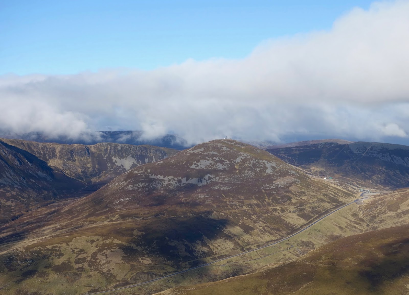
Glenshee ski area from Creag Leacach
Monday, 29 October 2019

Ascent:      952 metres
Distance:   16 kilometres
Time:         5 hours 16mins

Creag Leacach         987m     1hr   7mins 
Glas Maol               1068m    1hr   59mins
Cairn of Claise        1064m   3hrs  12mins
Carn an Tuirc           1019m  4hrs  2mins

A cold spell had brought some dry clear days on the cusp of winter so I arranged with John to go to Glenshee to climb a couple of munros that he needed to visit now that he has climbed the In Pinn and believes a fourth-round compleation is a possibility. I suggested we add a couple of adjacent munros to make it a more satisfying day. We had agreed to meet at Guildtown, south of Blairgowrie at 8am. This would allow John to make a 6:00am start to get round Edinburgh before the traffic was completely clogged. It was not to be, he spent an hour on the ring road to the bridges, meanwhile, it took me almost half an hour to get through the Broxden roundabout and Perth. It was 8:45am before John arrived and after 10:00am by the time we arrived at the Glenshee ski car park and prepared for the walk.

It had been a hard frost and de-icing the car had taken some time but perfect blue skies persisted until the final 5 miles with clouds hanging over the hills we were due to climb. There are a number of tracks that lead up to the ugly assembly of ski tows below Glas Maol but they speeded the ascent.  We found a narrow path that contoured from Meall Odhar below Glas Maol and onto the long ridge adorned by a fine wall that leads to Creag Leacach. The clouds were dispersing and it was an enjoyable walk with Beinn a' Ghlo draped in snow to the west and the ever visible Schiehallion a distant grey pyramid to the south-west. The final section to the summit requires the passage over several rocky humps where we saw several hares with their coats changing to white in anticipation of the snows, last year the November snowfalls were the only time that gave snow cover in Glenshee and skiing was virtually non existent. There was a cold wind and even stopping for 5 minutes at the summit brought on the shivers, we were not dressed for winter and needed to get moving again. 

Glas Maol is a great grassy hump and required reversing the walk back from Creag Leacach for a couple of kilometres. We were then faced with a steady plod to its summit cairn, which is made invisible by the convex slope until the last 100 metres. We met a walker who had been ahead of us, he had climbed the hills via Glen Isla. When he heard that we had been here before he began to ask numerous questions about hill walking, he had only recently started and was already captivated but unsure of what he needed to know. When the subject got onto ticks, John began a long explanation and then another walker arrived who was equally loquacious about the blighters so it became a tickathon. I decided to take a seat in the shelter and have some of my lunch, John eventually joined me. We did not linger long, the cold was once again seeping into us and movement was required.

We continued the walk by heading north down the long grassy north slopes of Glas Maol before hitting a track that meandered through an almost level area of peat before climbing towards Cairn of Claise. The wind had dropped and we made good time arriving as the sporadic sun was closed out by cloud. It was warmer without the wind so we had a relaxed lunch break in the knowledge that we would be down by 4pm, this would allow us to miss the traffic in Perth and Edinburgh. The walk across to Carn an Tuirc involves very little descent and even less climbing. It is a promenade across spongy moss, heather and grass and, for the final incline to the summit, a stony path across to an untidy cairn. It is not one of Scotland's grander peaks.

We were joined on the summit by a couple from Ballymena in Ireland. After several conversations at the summit and as we began the descent by following them to the north to find the path back to the A93, we walked out together. They took all their holidays in Scotland and he had climbed the munros 3 times in 15 years. They had an old camper van and thought it was the best thing they had done, selling motorbikes and boats to buy the van. They had a Border Collie that was perfectly behaved and could find the route off any mountain by reversing the route up. They had parked at the end of the path as they had been out to Tom Buidhe and Tolmount and kindly offered us a lift up to the ski car park where we were parked. It had been a splendid day despite the weather being less promising than had been predicted.


Ski lifts on Glas Maol
Creag Leacach
Ski area from Creag Leacach
West to Beinn a' Ghlo from Creag Leacach ridge

John writing his log on Creag Leacach
Descending Creag Leacach toward Glas Maol
Maol Glas summit
Cairn of Claise summit looking back to Glas Maol
Carn an Tuirc from the descent
Allt Garbh chairs


Monday 28 October 2019

Gowan Hill, Stirling

Wallace Monument and Ochils from Gowan Hill
Gowan Hill is one of those places that is a hidden overlook, sitting just a kilometre north of Stirling's city centre. It provides the most wonderful panoramic views of the Forth Valley, the Southern Highlands, the Ochils and the Wallace Monument. When working it was my favourite haunt if I had half an hour over lunch to escape from meetings and communications overload. There are paths from the City Centre and Castle via Lower Bridge Street and Crofthead Road respectively that climb through the wild parkland to Gowan Hill. It is surprisingly unvisited and on most days you get a viewpoint to yourself. It would appear from the litter around the benches that the area is used for drinking sessions in the evening.

I had a meeting in Stirling and left my car to have some tyres fitted at the Back O' Hill Road. I climbed Gowan Hill by a long steep ramp of stone steps across from the large Sainsbury Store. It was a perfect Autumn day and with fifteen minutes to spare I visited the Beheading Stone where King James 1 disposed of his enemies. There are two cannons directed towards the Wallace Monument. As expected there was no one else on Gowan Hill.

The visibility was excellent. The views of Ben Vorlich and Stuc a' Chroin were quite stunning in the morning light and made me wish I had gone climbing instead. Then I began to examine the urban topography of Raploch and its surroundings. I recalled the gestation of all the developments that have taken place over the past twenty five years. Sainsburys, the new Community Campus, Castle Business Park, the Park and Ride facility, the new Back O' Hill road, and several new housing schemes have transformed the area between the Hill and the River Forth. It was a trip down memory lane because they all have complex back stories that was a large part of my working life. Several of the businesses that had taken premises in the business park and now seem to be well established were also the outcome of tricky negotiations.

Beheading Stone
Raploch and Cornton
Raploch
Wallace Monument and Dumyat Hill
Stuc a' Chroin and Ben Vorlich and Braes of Doune Wind Farm

Sunday 27 October 2019

Lomond Hills, Fife

Approaching East Lomond
The Lomond Hills in Fife have passed me by on numerous occasions when travelling to meetings or events in St Andrews or Fife House, Glenrothes. I had always promised to stop and run them at the end of the day but time and work conspired against it. I had been looking for a decent spell of weather in the far north but nothing was doing. I noticed that Sunday was fine in Fife so I decided to make an excursion to climb them. Gregor agreed to come along and he would run them along with Bishop's Hill, and the shore path around Loch Leven to give him a 25 kilometre run to Milnathort where I would collect him. 

It was the day the clocks went back,  always a special day for the hills.  It was the weekend of the Karrimor International Mountain Marathons, which I had competed  on 13 occasions between 1976 to 1998 and the Snowdon Marathon that I ran in 1988. The extra hour meant that we could make a lazy start and still be walking or running by 9am from the Craigmead car park that sits on the saddle between West And East Lomond. There were only four cars there when we arrived. It was barely above freezing as we started out on a crystal clear morning with blue skies and a strong northerly breeze.

Sunday 27 October 2019

Lomond Hills

Ascent:     526 metres
Distance:  11 kilometres
Time:        2 hours 14 minutes

East Lomond     434m        23mins
West Lomond    522m        1hr 33mins

We decided to take in East Lomond Hill first so that Gregor could continue from West Lomond Hill to Bishop's Hill and then drop down to Loch Leven and follow the trail to Milnathort. The ice on the rocks on the initial section of the path was thawing and the first kilometre of the path was an easy pull before the final 100 metres of ascent to the summit on a grassy path. Gregor passed me on his descent at this point, the last I would see of him until Milnathort. The wind at the summit was not welcoming but it was trumped by the glorious patchwork field pattern of Fife displaying all its autumnal shades. I spent a few minutes inhaling the air and the views before descending by the same route. I passed another 3 walkers and 2 runners on their ascent.

I had intended to collect my rucsac at the car park for the ascent of West Lomond but there would be no need of it in these conditions so I stopped for some water before continuing on the longer of the two walks.  The path makes it an easy ascent, initially over short grass and then a wide stony path that climbs at a gentle gradient. The final 110 metres is the real climb and there is an option of a direct ascent up a steep path on a slightly muddy path or a half circuit of the hill at a more relaxing gradient. I chose the former and it proved no bother, I was walking well. The summit has a trig point on a stony base that seems to be eroding rapidly. The sun was higher in the sky and the views were not as clear as earlier in the day but Fife was dressed in its Sunday best. The Forth estuary provided a shimmering silver boundary to the south punctuated by Inchkeith, a perfect isosceles triangle. 

There had been few other walkers on the ascent but on the return to the car park the number of people exercising was impressive. I counted 29 women, 25 men, 12 dogs walking up the hill along with a lone runner and 6 mountain bikers. It confirmed the impression that I have had in recent years that there are as many women as men now enjoying the great outdoors and that mountain bikes make a mess of the grassy footpaths. I have no qualms about mountain bikes on tracks and hard trails but too many paths on the hills are being badly eroded by bikes. The car park at Craigmead was full as people began their walks. It was just after 11:00am and my exercise was over. I drove back to Milnathort and arrived within minutes of Gregor, we had really made the best use of the morning and we could now look forward to the Liverpool game. 

 G Descending East Lomond
East Lomond summit
Ballo Reservoir and West Lomond from East Lomond
West Lomond from East Lomond 
West Lomond ahead
West Lomond
Fife from West Lomond Hill
West Lomond and Loch Leven
Path from West Lomond
East Lomond from West Lomond path


Monday 21 October 2019

Stronend

Stronend view to Ben Lomond and Arrochar Alps

Sunday 20 October 2019

Ascent:      410 metres
Distance:   10 kilometres
Time:         3 hours 12 mins
Stronend   511m    2hrs 25mins


Stronend is the highest point in the Eastern Campsies and visible from the house. It was time that I climbed it as it is a Marilyn as well. Gregor had run up it a month ago and said the panoramic views from Stronend of the mountains spanning from Ben Lomond to Ben Vorlich were quite stunning. However, the route from Kippen via the Boquan burn required crossing 3 kilometres of an upland peat moor on a not very reliable boggy path. He was right on both counts.

It was the sort of autumn morning that beseeches you to get out and as Gregor was going to Glasgow I got him to drop me off near Garrique Farm on the backroad to Fintry. There is an excellent track that climbs steadily alongside the Boquan burn until it breaches the continuous line of crags at the Spout of Ballochleam. The views to the north are sublime from here with the mixed woodlands and Flanders Moss rising into the highlands beyond the boundary fault. There have been several new plantations of woodland that are passed on the ascent that have been funded by the EU. As you arrive at the gate at the top of the track there is a helpful sign explaining the importance of the upland moor for carbon capture and giving a list of the bird species to be found on this hostile upland environment. 

A track continues to the Ling Hill wind farm that had 25 or so turbines whirring at a good generation speed in the strong northerly wind. I entered the boggy ground on what was the relatively unused track and headed alongside the Boquan burn for a while until the depth of the sphagnum moss and the boggy ground was impairing progress to such an extent that I decided, wrongly, to head south to reach higher ground. I had thought that this would give easier conditions but it became 45 minutes of battle with heather and sphagnum moss. It was an extreme workout for my ankles and thighs as I fell half a dozen times into the channels of bog that meandered between the tussocks of deep vegetation. I began to think that the two black kites that were circling above were awaiting my final collapse.

At last, I reached the summit plateau by the 482m spot height and from there it was an easier walk to the large block of stones at the summit. The views were all that had been promised and I spent 10 minutes or so enjoying the panorama to the north-west as I examined the map on my phone. I decided that I would try to find a route off to the west and drop down to Fintry. I was pleasantly surprised to find a notch in the crags to descend to the flank of the hill that is called Skiddaw on the OS map.

I phoned to arrange my lift home from Fintry not Kippen before following a wall that had a faint path running alongside. It curved round to the west and steepened so I decided to head straight down to the road and became trapped in a long slope of prickly gorse bushes. It required me to search out gloves before I could extricate myself from the nasty stuff. I negotiated a ditch and fence and descended through a forested area scattering some roe deer before reaching the lush grazings than ran down to the road. The descent had certainly been a lot quicker than would have been a return by the ascent route. It had also provided a fine traverse to admire the setting of the village of Fintry and observe the scarp slope of the western Campsies. On balance, the outing had been worth it but I doubt if there are any regulars for this hill.

Looking west over Kippen Moor to Ben Lomond
Ballochleam and Ben Vorlich to the north
Boquan burn cutting through the moor
Ling Hill Wind Farm from the moor
Stronend summit
Ben Venue, Ben More and Ben Ledi from Stronend
Ben Lomond from Skiddaw
West to the Campsies and Earl's Seat
Stronend showing descent route by the nick in the crags

Fintry


Monday 7 October 2019

Puglia: Lecce and Gallipoli

Gallipoli

Whilst we were in Puglia we made visits to the two main towns of the south, Lecce and Gallipoli. Lecce has both a Serie A football team and a reputation as the Florence of the south. This is superbly covered in the Never Ending Voyage travel guide. We spent several hours in the town during our journey to our Pajare in Specchia. Lecce is a busy university town, although most of the students and many school pupils were demonstrating in the historic centre for action on climate change. We were impressed by their commitment until we saw the plastic bags and bottles that had been disposed on the streets after the fast-food outlets had been scavenged. The medieval town was contained within walls with a massive and impressively carved gateway. The Roman amphitheatre was being improved and surrounded by scaffolding but otherwise the town captivated us with its narrow streets, piazzas, churches and friendly ambience. There was little traffic within the centre, pedestrians ruled. Tourists, even at the end of the season, were being pursued by hawkers whose persistence in selling bags and clothing was distracting.

We were still an hour away from Specchia where we were to stay for the next five days so we spent the afternoon absorbing the atmosphere of Lecce. At a late lunch, we met a vocal American lady and her husband. She had worked for the federal government and was very disparaging about her president. They were on a long holiday to escape the daily embarrassment of his tweets and irredeemable lack of statesmanship. She hoped that impeachment hearings would have started when they returned home to North Carolina, which had voted for Trump in 2016. She was a Europhile and couldn't believe why the UK wanted to sacrifice membership of the EU for a trade deal with the USA. "We sure as hell will take advantage of your predicament" was her take on this.

We had a day trip to Gallipoli later in the week. It was quiet at the end of the season and we were able to park close to the bridge that links the original walled city to the modern town. We walked around the perimeter of the city along the high protective sea walls and I had octopus for lunch, which was a mistake. We visited the cathedral and bought an ice cream cone that was the largest ever, it was a slow day for sales. Returning past the new harbour built for pleasure craft, we were reminded that this had been the largest port in Italy for olive exports.

The modern town seemed prosperous compared to other small towns in the region but lacked the atmosphere of the original city so we began the journey back to base.There is a good 6-mile of sandy beaches to the south of the town but we drove on to Torre Mozza where we were tempted to to spend for a couple of hours on the beach as the sun sank over the Ionian sea and I managed a leisurely swim swim before returning to our Pajare.

LecceTriumphal Arch

Lecce Roman Amphitheatre

Piazza del Duomo

Add caption

Lecce Cathedral in Piazza del Duomo

Baroque sculptured interior of Lecce Cathedral
Gallipoli harbour
Gallipoli fortificatiobs


Friday 4 October 2019

Puglia: Salento

Marina di Novaglie

After our time in the Taranto region, we had travelled down to Salento, the heel of Italy, to stay in a modern Pajare (based on the squat square peasant cottages built out of local stone). There were 16 Pajares providing a minimalist but comfortable space in an olive grove that had been in the family for many years. Imulicchi was located equidistant from the Ionian and Adriatic seas on the brow of a low limestone ridge and run by a couple who had created an oasis of relaxed solitude. The breakfasts of local produce, the abundance of figs on the trees that surrounded the Pajare and the attention to detail and kindness of the hosts added to the pleasure of the stay.

The olive trees in Puglia are being killed in their millions by a pathogen that has arrived from Central America. It is spreading at an alarming rate and the owner of Imulicchi was going to rip out all the dead olive trees once the last visitors left the following week. This was the first year that the trees had produced no olives. Given that Puglia provides 40% of Italy's olives, this is a devastating blow to the economy, which is increasingly focused on agritourism.

From Gallipoli in the west to Otranto in the east, the coastline is dotted with new apartments that are second homes to Italians from the north. The beaches are clean, safe and mainly free, unlike other parts of Italy. Otranto is a lively resort with its ancient harbour and town at the heart of the busy commercial heart adjacent to a curing town beach that is clean and well used. It was Sunday and the throngs of locals made it difficult to find a table for an early lunch. Thereafter we drove up the coast and discovered the beaches at Torre San Stefano and whiled away a few hours reading and swimming.

There are many rocky headlands with deep inlets such as the remarkable stone pool at Marina di Novaglie just north of Leuca, the town on the southern tip of Puglia. At this time of year, the crowds have gone and the sea is calm and warm. Most of the cafes and restaurants have closed so we would spend hours on the beaches, the afternoon sun was no longer raging but still 28°C so we could take a swim every time the dry heat prompted the urge. Our regular beach was at Torre Vado, just 15 kilometres away from our Pajara. The dry afternoon heat was set at an ideal temperature and ice creams were available at a modern well-managed beach restaurant that oozed Italian style.

We stayed near the quiet inland town of Specchia that had a wonderful piazza, a clock tower that emitted long peels every 15 minutes and was the meeting place for local residents as they engaged in animated conversations in the open-air cafes and bars. Another local small town, Tricase, also had buildings that embodied the best of Italian style and culture. They were both places to sit and enjoy the atmosphere that good urban design engenders. Many of the smaller villages were less attractive with ugly 20th-century concrete houses lining the narrow streets that were a nightmare to negotiate. We also made two trips to the major towns of Lecce and Gallipoli that both rewarded us with all the best features of historic architecture and were designed for community living.  It is said that time stands still in Puglia but it raced along during our stay but the day we left was the day that the weather changed so our timing had, for once, been perfect.

We had an easy two-hour drive to Brindisi where it took no more than 10 minutes to return the car and enter the airport. It is a modern, efficient airport and built at a scale that makes flying attractive. It was not so arriving back at Gatwick, where we had to negotiate over a kilometre of corridors, escalators and moving walkways before finding customs, and then find the shuttle train to the railway station located at the other terminal. The sooner we eliminate these dreadful hub airports the better. Neither Heathrow nor Gatwick should be expanded, they are dispersed cathedrals to carbon emissions and have already far exceeded the size that any rational customer can tolerate.

Imulicchi Pajare

Pines at Imulicchi

Dead olive trees

Imulicchi landscapes

Marina Serra

Otranto town beach

Otranto harbour

Otranto

Otranto, a 50 feet drop on the other side

Torre San Stefano

Torre San Stefano

Torre Vado