 |
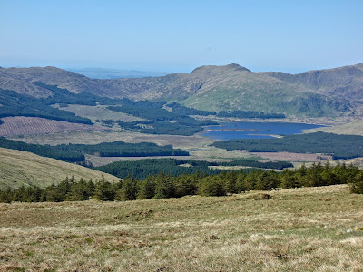
| Corserine from the approach through the plantations |
Thursday, 2 June 2016
Ascent: 1067 metres
Distance: 17 kilometres
Time: 4 hours 44minutes
c Corserine 814m 1hr 37mins
dt Millfire 716m 2hrs 25mins
d Milldown 738m 2hrs 40mins
d Meikle Millyea 746m 3hrs 5mins
 |
| The walk in along Birger Natvig Road |
 |
| View south from Corserine summit |
 |
| Merrick |
 |
| Merrick to Shalloch on Minnoch |
 |
| Over Loch Dee to Curleywee |
 |
| Rhinns of Kells from Meikle Millyea towards Corserine |
 |
| Loch Dungeon and Corserine |
A week of near-perfect weather in Galloway looking after grandchildren and enjoying the sumptuous local produce, glorious landscapes and pottering around towns and galleries left me desperate for a hill walk. Corserine is one of four corbetts in this part of the world and the only one I have not previously climbed, although Shalloch on Minnoch was during a mountain marathon and visibility was washed out so I will need to repeat it at some stage. We were staying near the comfortable market town of Castle Douglas and Corserine was not much more than a 35-minute drive away including the drive to Forrest Lodge in the
Fred Olsen Forrest Estate.
The extensive conifer plantations that radiated from the car park were along tracks named after Scandinavians and meant a good examination of the map was required before setting out to climb the track to the foot of Corserine, I had left the house at 6:45am so walking at 7:30am meant that I was enjoying the coolness of the early morning sun and the clearest blue sky imaginable. I had bought a map of the area to help me through the maze of forestry roads but there were signs for hillwalkers that took me to a stile over a deer fence and the open hillside of Corserine. The route out to Corserine is along Birger Natvig Road.
The path was distinct but narrow and it twisted up the steepish slopes leading to North Gairy, the eastern ridge of Corserine. Maybe it was the time of day but the climb seemed an easy ascent and I was soon on the ridge leading to a cairn at the eastern end of the plateau. I could see the trig point 500 metres away and I bounced across the springy turf to the summit. This was easy walking. The views over to Merrick and Shalloch on Minnoch opened up to the west across the complex Galloway topography and the views to the south were splendid with Loch Dee, Curleywee hill and then the Isle of Man a faint outline on the horizon. It was a bit of a promenade from here heading south over the three hills that form the Rhinns of Kells. I changed into shorts as the morning heat soared and ambled down the long slope from Corserine. I had previously taken part in two Mountain marathons here in 1976 and 1996 and it had rained continuously. Maybe this was the reason why I not returned for 20 years but today compensated for the rigours of the past.
Millfire and Milldown are gentle summits involving little climbing. There is a steeper and longer slope up to the final Donald of Meikle Millyea. The guide book had mentioned that the higher top was not at the trig point according to Harvey Maps but was 400 metres to the south-west. With time on my side, I trekked over and sure enough, it was 5 metres higher according to my altimeter. The descent from Meikle Millyea is to the northeast is down more rocky terrain but with stunning views into the crystal clear waters of Loch Dungeon. I was too intent on keeping to the edge of the ridge enjoying the views into the corrie to notice that I had deviated from the path and the crags below prevented any further progress. I had to turn south to refind the path to the edge of the forestry plantation. Again I was careful to take the correct turnings and it was an easy descent down Professor Hans Helberg Road to the car park. It was just past noon and I was back at the cottage before 1pm. I could get used to these shorter walks.


No comments:
Post a Comment
thanks