Tuesday, 15 March 2016

Beinn Bhan, Applecross

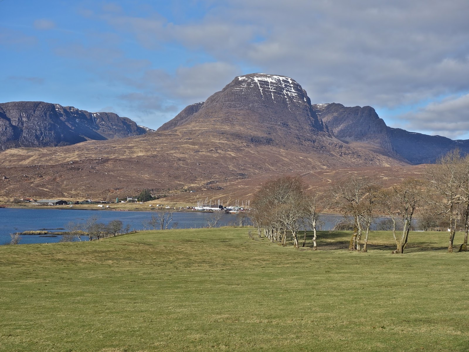
Beinn Bhan and its Coires from the east
Monday,14 March 2016
Ascent:      791 metres
Distance:   15 kilometres
Time:         5 hours 44 minutes

c   Sgurr a' Chaorachain     792m              1hr   3mins
c   Beinn Bhan                   896m              3hrs 34mins

This was the finest morning of the year so far as we woke in the superb cottage by Loch Carron. We decided to climb the two Applecross corbetts, Beinn Bhan and Sgurr a' Chaorachain. The drive round Loch Carron gave us the chance to see the north west highlands at their scintillating best. There were two couples so we took both cars to the foot of the Applecross road and dropped one there. The Bealach Bhan road was quite busy for an early March morning with a few cyclists testing themselves on gradients that used to defeat cars in the 1950's. My father had to reverse his ageing Rover 75 up the steepest section in the early 1970's on one of my parents many incident packed Scottish holidays.

Arriving at the summit we soaked in the views across to Skye and then booted up for the day's walk. Our wives continued on to Applecross to explore the shell sand beaches and to have an al fresco lunch in the excellent hotel whilst John and I began the climb up the track to the TV transmitter. I had been here a couple of years ago in the evening after travelling on the coast road from Shieldaig and I decided to run out to the corbett, Sgurr a Chaorachain, or so I thought. It was only on checking on a map later that I realised the cairn that I had reached beyond the TV mast, whilst almost the same height as the summit, was two kilometres of undulating ridge away from the true summit.

A couple of four wheel drive vehicles passed us going up the track to the TV mast before we turned off the track to head south to find the real summit. There were large patches of snow between the old red sandstone outcrops and the walking was illuminated by spectacular views into Coire a' Chaorachain including the massive cliffs that had been first climbed by Tom Patey and Chris Bonnington. Arriving at the summit was to reach the perfect perch for a long lazy lunch. It was still too early so we spun out the time taking photographs and then taking some food before the long leg over to Beinn Bhan. We retraced our steps to near the TV mast and then headed north for 3 kilometres over tricky rocky, boggy and heather strewn ground to Bealach nan Arr. It took a long time with constantly undulating ground, hidden dips, rock ledges, boulders and bog impeding our way.

The next leg was a 300 metre climb to the summit of Beinn Bhan climbing over rocky ground that was interspersed with long bands of soft snow. The gradient lessened as we climbed and eventually we arrived at the large cairn sitting on the long north to south summit ridge of Beinn Bhan. It had taken two and a half hours so we finished whatever food we had and began to take in the views and then explore the eastern edge of the ridge where the famous five corries scallop out the ridge. There were cornices all along the edge and the A' Chioch ridge looked unscaleable in the conditions.

We eventually and reluctantly started the long descent to the south, exploring the edge of the ridge and viewpoints as we dallied at each point on the ridge as the late afternoon sun cast longer shadows. We heard the distant call of a plover,  the only wildlife of the day.  The descent gets steeper the further along you walk but we remained in the sun until the last kilometre of the ridge. We had a further kilometre along the road to the car and were surprised at the amount of traffic returning from Applecross.

The views over Kishorn were impressive and generated a conversation about why Kishorn had been built as a deepwater site for the construction of offshore drilling rigs. I had been working with the economists in the Scottish Office who were evaluating alternative sites for rig construction and my contribution had been to tell them not to mess up this spectacular part of Scotland. They dismissed my arguments as giving too much weight to environmental factors, these were not perceived as important in the 1970's. Nevertheless no rigs were built here despite the initial site works being constructed. Nigg Bay and Ardersier were far nearer the oilfields in the North Sea and had a far better transport infrastructure for bringing in materials as well as accommodation for workers. And the damage to the  environment would be far less intrusive, although Nigg Bay does now look like a graveyard for some of Andrew Gormley's sculptures on steroids.

But enough of bashing economists, they are fallible, unlike the walk today. It fulfilled the ultimate goal of well being that economists generally dismiss - sheer pure happiness.

Sgurr a' Chaorachain from Kishorn
Skye Cuillins across the Inner Sound
Lookong along the ridge to Sgurr a' Chaorachain 
TV masts above Coire a' Chaorachain from the summit
Rough going on the route to Beinn Bhan
The route up Beinn Bhan

Afternoon shadows

Looking north to the Torridons
Torridons from Beinn Bhan summit
Overlooking Coire na Poite

Last of the winter white on Beinn Bhan
Beinn Bhan from the south ridge

Monday, 14 March 2016

Meall Dubh

Meall Dubh Summit Cairn, not easily missed

Route from Glen Moriston
Sunday, 13 March 2016
Ascent:     670 metres
Distance:  10 kilometres
Time:        3 hours 44 minutes

Meall Dubh        788m      

Birthday or no birthday, this is the year of the Corbetts, and by that strange fluke of mathematics, I now have as many left to climb as I have years on the clock of life. Time waits for no man and I would happily reverse the direction of age and Corbetts. Meall Dubh is a modest hill that sits alongside the A87 on the road between Invergarry and Loch Cluanie. John and I have talked about climbing it for the last twenty years. We were always either charging north to climb some Munros or driving back too late or tired after several days of walking to tackle this Corbett that sits alongside the extensive Millennium wind farm. We were heading for a week at Strathcarron and after meeting up for a light lunch at Invergarry we had time to complete the hill before nightfall.

Instead of parking at the dam on the A87, we decided to follow the route from Glen Moriston which is the more usual route nowadays utilising the track to the Millennium wind turbine field that sits east of the hill. The starting point is 3 miles east of the junction with the A87, with a large parking area on the opposite side of the road. There is a walker's gate onto the track that twists its way up the hill and passes through some plantations. At about 400 metres, a junction and the road to the right head towards the outlying northern summit of Beinn an Eoin. At the high point of this track, we turned off to the left, climbed up and over some boggy ground, and eventually found a place to cross the still-swollen Allt Coire na Gaoith an Ear. Then we headed for the southern ridge of Meall Dubh climbing up steeper heather-clad slopes until we found the drier ground of the ridge.

It was a grey afternoon but the views were good, we were close to the massive wind turbines, some of which were turning lazily in the whisper of a breeze. We had a couple of snowfields to cross before reaching the massive summit cairn. We had watched a lone walker disappear from here to the south about 5 minutes before our arrival, a sure sign that the Corbett bagging season had started. The views to the west were impressive. Loch Cluanie was trapped between the snow-capped peaks of Glen Shiel whilst Loch Quoich pointed towards the Knoydart hills, indistinct peaks on the hazy horizon.

After a break at the summit, we took a more direct route down the ridge, taking advantage of some snow chutes and arrived at a recently erected footbridge over the Allt Coire Gaoith an Ear. From here a rough track climbs 50 metres to where we had veered off on the ascent. The light was fading as we retraced our route down the track and arrived at the car just before 6pm. The sense of accomplishment was along the lines of 'well that's got that one out of the way'. The real birthday treat was an hour or so later when we indulged ourselves with a fine seafood meal in Plockton. The weather forecast for the next few days was just as exciting as uninterrupted sunshine as forecast in the northwest highlands and this in mid-March.

On the start of the ascent from Glen Moriston

Millennium wind farm

Loch Quoich, Loch Loyne and Loch Cluannie from summit

The bridge over the Allt Coire Gaoith an Ear

The track above the bridge


Friday, 11 March 2016

Race Marshall

Forth Inn the registration point

I spent last night marshalling for the Trossachs Night Trail race, spending over an hour in freezing conditions and then collecting tape and signs before walking back from my marker point, I was the last man back to the pub which acted as the registration point and prize-giving space. I collected my free beer and gel (do I need to declare these?) and watched as the results were churned out for the three-race series. I wished I had entered there was an M60 prize and it would have been less cold than marshalling but I have been down with a heavy cold all week and not running.

It has been a long time since I was involved in race organisation. In the 10980s I had set up an employee-running club for Strathclyde Regional Council, partly as a campaign to have workplace showers for those of us who ran to work. We organised five or so races a year, mainly 10k races in Pollock Grounds using the Strathclyde Police Sports facilities. We had a staff of over 100,000 and the events would have entries of up to 200 runners. We also entered the UK local government national championships with some success and we were asked to host the national championship. We organised the event in Strathclyde Park and I set the route, made the announcements on the day and ran as part of the team which won the team prize.  I don't think I appreciated the loneliness of race marshals or their stoicism.

The Trossachs Night Trail series was the brainchild of Angela Mudge, who lives locally and is a legendary figure in the hill racing circuit. When she calls and asks you to marshal you don't argue. Anybody who cycles across Europe from north to south, because she was injured and could not run, is not to be disobeyed. 65 runners turned up for the last race in the series of three. Over five miles around the forest with tricky twists and turns and a fast grassy descent down to the finish. It is not an easy route in the daylight but the hill runners lapped it up with their unbounded thirst for adventure aided by head torches that strobed the ink-black night.

Standing on the forest track waiting for the runners to appear was an eerie experience, there was little light pollution and I had to direct them from the fast downhill gravel track around a sharp bend and onto a steep descent with another marshal at the bottom shining his clockwork lantern. I expected the first runner half an hour after the start and he appeared slightly early, his bobbing head torch visible when half a mile away. Twenty-five minutes later the last runners passed through and it was time to gather the tape and signs and make the way back.

After the prize giving I spoke to the winner on the night and of the series. Joe Symonds was the first winner of the Glencoe Skyline race last year and has an impressive palmare of wins in mountain marathons, and hill races as well as some impressive times on the road. His father, Hugh Symonds, had written a book in 1991 about his 83-day epic run around the Scottish Munros. It was one of the books that inspired me on my first Munro round but it took me 92 days over four and a half years. Hugh Symonds had taken time off his work as a teacher and was accompanied by his wife and three children in a camper van; Joe was six at the time. Hugh also had help from the band of fell runners from the Lake District including Mick Walford, an old acquaintance from my school cross-country team. 

Joe told me that the trip was the best part of his education, it taught him so much about living simply, the environment, and how to set goals. It also nurtured his love of the Scottish mountains where he moved on leaving school to study and then work. His father had retired from teaching and spent his time cycling around the world with his wife. There was a sense of fulfilment from Joe, not the sort that emanates from an Amazon parcel, but the sort that comes from someone who has set out clear goals and works and plays hard to achieve them. He also has values that are focused on the environment and an active lifestyle. 


Thursday, 10 March 2016

Rob Roy Way: Aberfoyle to Drymen

Ben Lomond from the stone bridge over the Forth at Aberfoyle
Wednesday, 9 March 2016
Ascent:      285 metres
Distance:    18 kilometres 
Time:          3 hours 14minutes

Aberfoyle to Drymen is the last section of the north-to-south Rob Roy Way that I have been dawdling over for a few years. On a day like today, it provides the very best of outings: relatively short but passing through some little-visited remote trails and a chance to admire the great Victorian engineering of the Loch Katrine to Glasgow water supply. My intention was to do the Rob Roy Way north to south instead of the more usual south to north route. I have failed not only to do all sections in the right order or from north to south, and I am only halfway through the walk. I am enjoying shuffling around the sections; each day is a surprise, a journey into the unknown, known parts of Scotland.


Beyond Balleich, looking north to Drumlean

Track junction west of Balleich

Clashmore, where the track doubles down

Mating season

Victorian water pipe bridge over the Keilty Water

Looking north to the Menteith hills and Ben Ledi

Caribbean Blue

Radio Mast at the top of the Gartmore to Drymen road

One of the few signposts a mile north of Drymen

Campsies from outside Drymen

It was a fine March day and after the frosts had cleared, I decided to walk the final leg of the north to south Rob Roy Way from Aberfoyle to Drymen. It is a half-day walk through the Queen Elizabeth Forest Park and then onto the top road from Gartmore to Drymen for the last 6 kilometres. With the weather sunny and no rain likely, I took the bare minimum - water, a banana and a jacket; and walked in just a pullover, jeans and an old pair of running shoes. It was cold but infused with bright sunlight.

As I passed through the village, I met Keith Graham, who for many years had written a country column for the local paper and was a keen cricket coach. We discussed the emergence of Afghanistan as a cricket nation; they had just beaten Scotland. Keith told me that the game was flourishing with some fine cricketers emerging. He then told me that Cricket Scotland had decided to relocate its HQ to Stirling, attracted by the excellent cricket facilities at Forthbank. It would be a justification of the decision by the Council ten years ago, when we had persuaded various sports clubs to relocate to Forthbank to release land for a new school and redevelop some dated facilities like the Rainbow Slides and the Ice Rink. It has paid off handsomely for all concerned.

The start of the walk leaves the village by crossing the bridge over the River Forth and heading south along Manse Road.  It is a route I do most days when running, but walking allows more time to take in the surroundings and admire some of the views. Balleich is a small hamlet with Forestry Commission workshops and a handful of houses. Beyond here, the track begins to climb, and you are in the densely planted coniferous forest that is changing all the time as felling operations are sweeping through the plantations, leaving swathes of open land blighted by tree stumps and punctuated by the odd limp birch tree that has been spared the chainsaw.

The track climbs gradually and is fairly straight with just one left fork to take before arriving at the isolated cottage at Clashmore. There was no one else walking or cycling along this section.  I allowed myself to be absorbed in a playlist of my favourite tracks that I had not heard for a year or so. On the day that George Martin had died, it seemed appropriate to listen to favourite Beatles tracks first before reverting to shuffle. All sorts of memories were revived as I became lost in the music. Led Zeppelin's Going to California was particularly nostalgic, reminding me not only of the then indubitable American dream, now a long-forgotten concept as Donald Trump milks the disillusioned blue-collar vote, but also of the final lyrics:

"Standing on a hill in my mountain of dreams,
Telling myself it's not as hard, hard, hard as it seems." 


These words had been etched into my mind about fifteen years ago as I cramponed my way up a slope of sheet ice on the way to a Munro summit in a February storm. Visibility was minimal, the wind was taking the breath away, and my hands were too cold to switch off my Walkman. I persevered on hearing that it was not as hard as it seemed. Then, Paul Simon's poignant and beautiful rendering of Father and Daughter , which I had played every Sunday morning on my runs after my daughters had gone to university. My pace lapsed as it always brings a tear as I reminisce on the joys of being a father to two daughters. Radio Ga Ga by Queen upped the tempo and helped me get back up to pace.

At Clashmore, there are a couple of options. I took the one to the left and realised when I got home and consulted the map that it was longer, but I had never ventured down this track before. The track twists through some low ridges. I kept to the right forks at each junction until arriving at a crossroads where I took the road to the left, which I guessed would bring me to the water pipeline. The pipeline is a massive and impressive feat of Victorian engineering that provides Glasgow with its water. I was relieved to pass a sign for the Rob Roy Way, although I could have saved time and distance had I turned right at Clashmore. There was some compensation; I witnessed a large puddle with twenty or so frogs, they were engaged in a mating frenzy, and it was effervescing as if it were a hot tub. I was then following the haphazard flight of a buzzard at close quarters as it tracked some prey.

It was good to escape the forest once I reached the water pipeline. It is largely buried but emerges to cross the Keilty Water, where the quality of the engineering is revealed in all its cast-iron glory. The track turns to the east towards the Gartmore to Drymen top road. I passed a woman walking dogs and then an elderly gentleman on an electric bicycle, he hollered at me, "What a wonderful day!". It was hard to disagree, and I was pleased to see the benefits of an electric bike for someone in his dotage. Something for the future, maybe?

I reached the road at the cottage and was disappointed to see that there were another three and a half miles to go. I had already covered 8 miles, and my normally comfortable running shoes were beginning to blister me. There is a long climb up the road until the Muir Park reservoir and then past the radio aerial at the highest point of 200 metres. A cyclist peddled past, his cadence suggesting a low gear, and then an elderly couple in a car offered me a lift and didn't seem to understand why I would turn it down. He asked me if I had done National Service, and I told him I was too young, at which he started to give me his full military history. The road was quite narrow, and he was driving alongside, so I stopped to adjust my shoe to escape any further instalments.

The final downhill section to Drymen is an easy walk of a couple of kilometres, although my blistered toes would dispute that. The views of the Campsies to the south-east were spectacular as the afternoon shadows lengthened. On the other side, there were glimpses of Loch Lomond and its smattering of islands. I had arranged a lift home from Drymen and arrived ten minutes later than I had estimated, but I had walked a couple of kilometres more than the recommended route. I am not sure what or when the next leg of the Rob Roy Way will be, but on present progress, it won't be in any logical sequence. I have acquired a taste for shuffling sections according to my mood, bus timetables and the weather.


Monday, 29 February 2016

Trains and trains and trains

The Good - Flying Scotsman on King's Cross to York Rail Museum 
The Good - Chiltern Railways -fast, cheap and new rolling stock
The Bad and pricey- Virgin Trains
The Bad and dirty - Cross Country trains
The Ugly, old and slow Northern Trains
What an absurd system of railways we have in Britain. Complex, disjointed and diverse, but not in a good way. My latest two-day expedition, getting from Scotland to London, captured all that is wrong as well as some of the good things about the rail service we now have to endure.

The journey was from Edinburgh to Sheffield for a training event, then on to Banbury for a family reunion and finally to London to visit our daughters. Three journeys, four trains, and four train operators with a set of advanced tickets bought online from Virgin Trains that required me to make a trip to the nearest railway station to collect the tickets. We set off with plenty of time to catch the train from Edinburgh. It took two and a half hours for what is normally a 50-minute drive to Edinburgh airport and a half-hour journey by express bus.

The motorway was clogged as a result of Scottish Water closing one lane of a dual carriageway into Edinburgh, causing a 7-mile tailback onto the motorway. They were not even working on the carriageway but on the adjacent grass verge. It took over an hour to cover these 7 miles, and Aileen missed her flight to London by a couple of minutes. British Airways acknowledged the unexpected traffic delays and transferred her to the next flight at no cost. Transport Scotland needs to excoriate Scottish Water for both the inappropriate timing and the unnecessary extent of their road closure. According to the airport, several hundred people missed their flights, whilst thousands of commuters were delayed. Getting to Edinburgh and its airport from the west and north is a hazardous occupation nowadays, and that will probably be further exacerbated when the new Forth Bridge opens.

Travelling on to Waverley station on the express bus, I missed my train by fifteen minutes. Virgin Trains charged me an additional £66 on top of my train-specific ticket for travelling on the next Sheffield train. The train was quite devoid of passengers, so it was a penalty for being a pay-as-you-go customer. It was the way we used to buy rail tickets when we had an integrated rail network. There was no customer sympathy; Virgin Trains has no positive reputation to protect, as they are more akin to Ryanair than British Airways. The well-worn carriages had been repainted in the garish Virgin train livery since they had taken over the franchise from the publicly owned East Coast trains. It was a pure marketing ploy and a great pity that they had not re-upholstered the seats or refitted the filthy toilets instead. But passengers are now reclassified as "esteemed customers" and a veritable cash cow.

The journey was on time, and passing York, I saw the carriages that the restored Flying Scotsman steam locomotive had pulled from King's Cross to York in the morning. The steam locomotive had been taken into the rail museum along with the celebrities who could be seen sipping champagne on the museum balcony. It is noticeable that the Flying Scotsman has been repainted in its British Railways dark green livery to remind us of the days when we had an integrated and comprehensive rail service across Britain. Heady days when train journeys had one price, timetables between routes were properly interlinked, and large stations were travel hubs, not shopping malls.

Travel times in the days of steam were much the same as now in much of the north of England, as I was reminded when travelling from Doncaster to Sheffield at a pace that seldom broke a mile a minute.  According to the Institute for Public Policy Research, spending on publicly-funded infrastructure in the north of England is just £223 per resident per year compared with £5426 in London. Underinvestment over decades has left northern England's rail network with poor average journey times between major cities, inadequate capacity, and ageing rolling stock. And it showed, many of the Northern trains were ancient multiple units that must have been around even before Slade first had a hit with Merry Christmas Everybody.

Arriving at Sheffield, I made enquiries about my onward tickets as I had inadvertently left my railcard at home. The helpful station staff explained that I would have to buy another one, despite it only being a couple of months old. It would cost £30, but that would be more than saved on the ticket down to Banbury. They explained that National Rail, which issues railcards and ensures a consistent ticketing style, is owned by the rail operators, and they do not offer replacements. The operators obviously have identified lost or forgotten rail cards as a significant source of extra income from the people formerly known as passengers.

The next leg of my journey was mid-morning and operated by Cross Country trains. The train was already fairly full, mainly with groups of women going on trips. Although I had a seat reserved, the ticket collector explained that they had not put out the seating reservation cards, so I would have to find an empty seat. A large group of Yorkshire women from Leeds were already opening their third bottle of bubbly; I asked them what the occasion was, and they told me it was Saturday. I cleared my seat of empty cans and sandwich cartons and tried to enjoy the scenery down to Derby and then Birmingham. My small suitcase did not fit on the narrow luggage rack, and when a man took the seat next to me at Derby, I had to tuck the case between my legs and the seat in front. Never have I arrived at Birmingham New Street with such glee. The man got off, and I could stretch my numbed legs into circulation. The train arrived on time at Banbury, where I spent the afternoon with the family of my recently deceased Uncle as we shared our memories of him over an extended lunch in a typical Oxfordshire village pub.

The final leg was the perfect journey, £3.95 for the 75-mile trip from Banbury to London with Chiltern Railways. Brand new carriages with comfortable seats, picture windows, uncrowded, a fast journey, clean and on time. Apart from the last 400 yards, when we had to wait 10 minutes for a platform to become available at Marylebone.

So what conclusions can I draw from this non-scientific but nevertheless 'mystery passenger' account of our railways? Well, the pricing structures are bizarre, the speed and price of travel are significantly better in the south, where the quality of rolling stock is infinitely better. We can all be nostalgic for steam locomotives but the biggest difference from those halcyon days of steam is not the motive power but the absence of fair and consistent pricing, the lack of uniform investment across the rail network and significant variation in the age and condition of rolling stock across the regions with the south-east, in particular, having benefited. 

Franchising has provided us with railways that are every much as unequal as income distribution and house prices in what was once the United Kingdom. John Major's rail privatisation has had twenty years to settle down, and we are frequently told of the vast increase in passenger numbers, but that is mainly in the southeast, where the investment has been focused. And it has come at some price to the pretence that we are a nation with an equitable distribution of resources. We are not all in this together; we live in a two-speed Britain, and the government intends to amplify this even further with HS2 and Crossrail. And as for the benefits of competition, well, try getting from Scotland to England without filling Richard Branson's coffers now that Virgin Trains monopolise the west and east coast routes to Scotland. The removal of Virgin Trains from holding any franchises would be my starting point for the resurrection of affordable, comfortable and efficient rail travel.

The evidence below is only one example of train journeys in Britain, but it reflects so many others that I have made in recent years.

Operator    Virgin Trains          Cross Country     Chiltern 
From           Edinburgh              Sheffield              Banbury       
To                Sheffield                 Banbury               London
Distance      251miles                113miles               75miles
Time            3hrs 38mins           1hr 53mins            56mins
Cost             £107                       £20                        £4
Cost/mile     42.6p                      17.7p                     5.3p
Av Speed     69mph                    60mph                  80mph


Wednesday, 24 February 2016

Rob Roy Way: Killin to Acharn

Dochert Falls, Killin

Tuesday, 23 February 2016

Ascent:          780 metres
Distance:       27 kilometres
Time:             6 hours 7 minutres

Creag Gharbh    637m     2hrs 13mins
Ardeonaig                        3hrs 38mins
Ardtalnaig                        4hrs 42mins
Acharn                             6hrs   7mins

After the coldest night of the year, there was the promise of a dry sunny day, although further north, there would be clouds and strong winds. I had hoped to climb some Corbetts, but the ones that I have left to climb are all in the north-west. I did not relish the prospect of a long drive and missing the rare chance of a decent day, so I decided to make some more progress on the Rob Roy Way. We had started three years ago on a north-to-south walk, but the next stage from Aberfeldy to Acharn was difficult to arrange as the public transport did not fit unless we left home at 6:30am to catch the school bus from Killin to Aberfeldy. So it had been put on indefinite hold. 

I decided that I should do the third section from Acharn to Killin on my own, as it includes a long road section and the highest climb of the route, which would also allow me to climb an adjacent Graham. The transport was still awkward, so I reversed the route so that I could start from Killin and hope to catch the school bus back from Acharn to Killin. This would also allow me to do the climbing first and leave the 15 kilometres along the road for the afternoon.

I parked in Killin just after 9:30 a.m. and began the walk by crossing the bridge over the River Dochart. It was still below freezing, and the falls were sparkling in the morning sun. The first couple of kilometres on leaving Killin were along the single-track road to Ardeonaig, and I was pleased to see that it had been resurfaced, although the timber lorries were making short work of wrecking the road edges again. At the bridge where the Achmore Burn descends to Loch Tay, there is a forestry road that climbs steeply for 4 kilometres to the Lochan Breaclaich reservoir. There were quite a few forestry operations in progress, and the views over to the Ben Lawers range were restricted by the plantations. There is a gate at the end of the forest and a radio mast before the final winding section of the road to the reservoir. I followed a path to the south end of the dam so that I could walk across it before climbing the rough track that runs alongside the reservoir, before climbing under Creag Gharbh.

Creag Gharbh is not on the Rob Roy Way, but a Graham nevertheless, so it deserved a visit. I left the track where it veers sharply to the right and began to climb through deep, soft snow. Despite the cold, I was soon sweating and found a sheepfold beneath the summit to put on some gaiters and take a drink. The final climb was hard work; each step was a thigh-deep plunge into the snow until I reached the summit ridge. The prominent cairn is a splendid viewpoint where I spent 10 minutes enjoying the views and taking photos. Unfortunately, the early morning sun had given way to a layer of cloud, but visibility was still very good. I had intended to return to the track, which would have given me an easy route down to Ardeonaig, but the long ridge to the northeast was too tempting. The descent was a tough workout through deep snow, peat hags and rough ground before I was able to cut under Stuc Mhor and reach the track down to Brae farm and from there the road down to Ardeonaig.

I knew Ardeonaig from my time as a returning officer. It had a polling station for elections, and when I organised an October by-election following the resignation of a Councillor in 1999, I visited the polling station, which was in an annexe of the hotel. There were only 49 voters on the register, and there was a poor turnout. My two polling clerks complained of boredom, the darkness of the location and the fact that the outside toilet was unusable as it was full of leaves. I spoke to a farmer's wife, from Ardeonaig, whom I knew; she was the polling clerk in a nearby village, where she always provided fresh fruit as a thank you to those who had voted. She told me that most of the locals in Ardeonaig went into Killin most days, and those who didn't could use a postal vote. Much as I was committed to providing everyone the chance to vote, I decided to close the polling station for future elections. There was no opposition from the local community.

My descent into Ardeonaig was new territory for me, I passed the large Outdoor Centre with its magnificent stand of trees and through farmland where sheep, goats and cattle were grazing before arriving at the Ardeonaig hotel on the Lake road. Although it was 1:20pm, I decided to push on; there was a long 14-kilometre walk along the single-track road to Acharn. The cloud cover had pushed in from the north, and it seemed cooler than it had been on the tops in the morning. There was little traffic, but nowhere to stop and enjoy the views and have some lunch. I kept walking until just before the next settlement of Ardtalnaig; I found a bridge with a dry stone parapet where I emptied my rucksack of food and drink.

Ardtalnaig does not have many houses, but a tennis court and a major waterworks pipeline project was in progress. I was walking at a fast pace as I began the last leg of the walk to Acharn. It was almost 3pm and I had no time to waste if I was to catch the one bus of the day from Acharn at 4:05pm. There were several expensive modern houses under construction near Kepranich, all taking advantage of the spectacular views down Loch Tay and across to the Ben Lawers range of mountains. The sun had also reappeared, and the afternoon had a springtime feel about it. The catkins were providing a hint of fluorescent green on the willow trees, which had colonised the badly broken stone walls that lined the road. Several people were gardening, and the traffic increased as the construction workers finished their day and the school car runs began.

I ran most of the last couple of kilometres to be sure of catching the bus, but I made it in good time, although the bus was early as it disgorged the local children and began its journey back to Killin. The bus is primarily for the pupils attending Aberfeldy Academy, and I was the only non-school passenger. The journey to Killin allowed me to observe my route for the day from the opposite side of the Loch and realise that, whilst it may have been a relatively flat walk apart from the Graham, 27 kilometres is still quite a distance.

Ben Lawers range

Tarmachan ridge across Loch Tay

The long winding road to Creag Gharbh

Across Lochan Breaclaich to Creag Gharbh and Meall Odhar

Lochan Breaclaich looking west

Ben Vorlich and Stuc a' Chroin from Creag Gharbh

Looking northeast to Loch Tay

Stobbinnein and Ben More from Creag Gharbh

Loch Tay looking east from the summit of Creag Gharbh

Killin and the Glen Lochay Mountains

The road between Ardeonaig and Ardtalnaig

Heading towards Acharn

Loch Tay and Lawers range are still in the cloud

The clouds lift

Fearnan across Loch Tay with the Glen Lyon hills in snow

Acharn