Monday, 17 May 2021

Glen Sligachan

John MacKenzie and Norman Collie statues at Sligachan

Saturday, 15 May 2021

We had walked every day since Monday in the north of Skye and felt we should pay a visit to the Cuillins. In my last 15 trips to Skye, that is all I have ever done, but rather than climbing the ridge, we walked along Glen Sligachan, a well-trod mountain path that provides a close-up view of both the Black and Red Cuillins. 

Gregor ran along the Glen to climb Sgurr na Stri, a comparatively small but rugged hill that is claimed to have the best views in Skye. He then dropped down to Loch Coruisk and ran back over the steep ridge and down Glen Sligachan, collecting a handful of Strava crowns along the way. We had a coffee in the revamped Sligachan hotel, enjoying the reopening of hospitality with cake and coffee. We did not have long to wait, Gregor had covered 25 kilometres in 2 hours 40 minutes over some of the roughest and steepest slopes. He was finally, after an epic week of runs, too tired for an evening walk.  

We returned to our Airbnb and had our first evening meal out since last July in the Edinbane Inn, and drinks were not allowed inside. Not that this matters; drink is a habit that I will have to reacquire after 14 months with virtually no alcohol, a real bonus arising from the Covid pandemic.

Sligachan River and Hotel

Glen Sligachan to Marsco

Marsco

Black Cuillin - Sgurr Dudh Mor to Inaccessible Pinnacle

Sgurr nan Gillean

Bla Bheinn

Crossing the river


Glamaig


Ben Tianavaig, Skye

Ben Tianavaig looking south to Red Cuillin

Friday, 14 May 2021

Ascent:        440  metres
Distance:     5 kilometres
Time:           1 hour 11 minutes

Ben Tianavaig    413m      41mins

We had spent the day touring the north of the island, three shortish walks near Uig, Flodigary and Staffin. Gregor suggested an evening ascent of Ben Tianavaig, which is just south of Portree and has claims to be one of the best viewpoints in Skye. He was going to run it so I dropped him as we turned off the A850 at Peinmore. It would give him a 4-kilometre warm-up run before the start of the climb from Tianavaig Bay, where I parked and started the climb. I was walking well, no stops and a reasonable pace or so I thought until he caught me before the halfway point of the climb. 

A Strava crown was his objective and he managed the 413-metre climb in 18:33, beating the previous record by 3 minutes. Donny Campbell, the holder of the fastest Munro round, was now 4th fastest and 4 minutes slower. Gregor had to wait 10 minutes or so, cooling in the evening breeze before I joined him on the summit. The views were all that the books had promised although the evening sky was cloudier than we had hoped. The descent was interrupted by photo stops but this is a near-perfect hill that has everything.

The ascent

Looking South

Portree from summit

Portree Bay and the Storr

G running down


Black Cuillin


Saturday, 15 May 2021

An Storr and Hartaval

An Storr from the Sanctuary

Thursday 13 May 2021

Ascent:         971 metres
Distance:      13 kilometres
Time:            3 hours 5 minutes     

An Storr         719m     1hr 14mins
Hartaval         668m     1hr 46mins 

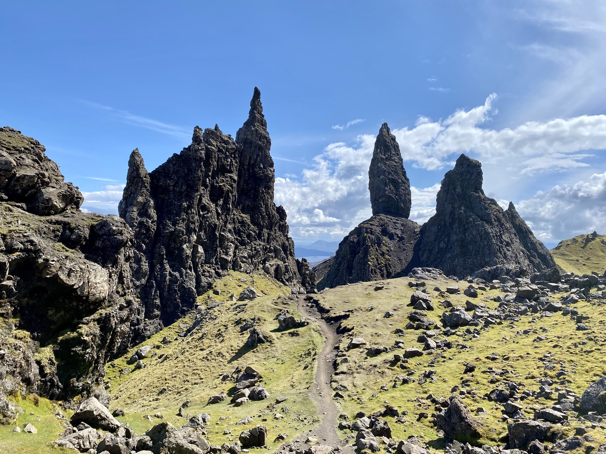
Gregor had wanted to run the Trotternish ridge but after running 50 kilometres in the past 3 days plus two coastal walks and an ascent of the Quiraing, he was understandably reluctant to start too soon. We dropped him by the Quiraing for him to start a run of the ridge from north to south at 11 a.m. Aileen and I travelled on through Staffin to the newly constructed Storr car park. It is limited to vehicles of restricted height which meant that the cavalcade of motor homes had to park along the roadside. An extra lane had been created to accommodate these ships of the North Coast 500. I had decided to climb the Storr first and then Hartaval before returning to the Sanctuary which is the area hosting the Old Man of Storr and other features of this remarkable landscape. Aileen was keen to explore the Sanctuary and have a picnic lunch before we returned.

The new path to the Sanctuary through the old forestry plantation that had been felled was steep with a well-constructed staircase. There were dozens of tourists making their way up and down. From the Sanctuary a narrow path winds its way to the north cutting under the cliffs at an easy gradient before reaching the end of the cliffs when it is possible to climb the grassy slopes and then turn and ascend the final climb of 200 metres to the summit of An Storr, a vast short grassy slope in complete contrast to the cliffs below. 

I had made good time and after a chat with a Liverpool supporter, I began the long descent to the Bealach a' Chuirn between the two hills. I arrived at the Hartaval summit just after Gregor so we had 5 minutes for some food and drink before he began the run over to the Storr. Despite at least a couple of hundred or so who had walked to the Sanctuary, I had only met 3 people other than Gregor on the Storr or Hartaval. I dropped back down to the bealach and then made a rising traverse to regain the path back to the Sanctuary. The sun had joined us and we all met up on a sun-soaked slope above the Sanctuary. Aileen was ecstatic about the place and we all enjoyed some time exploring the Sanctuary before returning to the car. 

Feeling pleased with the outing we drove to Portree and spotted a pub with outside tables. For the first time since last summer, we stopped for a pint and treated ourselves to a late pub lunch. The fish was fresh and the perfect way to celebrate a taste of the Trotternish ridge or in Gregor's case to make a complete meal of it. 

Stone steps to the Sanctuary

The path leading to the top of the cliffs

The Storr summit

Hartaval summit

The Storr from Hartaval

Looking south to the summit of the Storr

Old Man of Storr

In the Sanctuary


Friday, 14 May 2021

Quiraing

The Needle and the Prison

Tuesday, 11 May 2021

Ascent:       410 metres
Distance:    8 kilometres   
Time:          2 hours 52minutes

Meall na Suiramach    543m   1hr 48mins   

It had rained all day as we drove up to Edinbane in the north of Skye on Monday.  Our stop at the Cluanie Inn for a lunch was a huge disappointment, this has been my regular break stop for 30 years when travelling to Skye, the Torridons or other mountains. It is well located and usually served reasonable food at the end of long days on the hills or refreshments when breaking a journey. Alas, under new ownership, they have refurbished the buildings but bumped up prices to absurd levels, £4.50 for a coffee, and the food we ordered was almost inedible as well as expensive. I won't be stopping here again.

Tuesday morning was not much better and we inflicted a two hour soaking on ourselves as we walked out to the coral beaches north of Dunvegan. It was with some trepidation that we headed north in the afternoon to Uig and then across the unclassified road to the car park below the Quiraing. Like much of Skye, the tourists have been well catered for by a large car park and, judging by the heavy usage on a late Tuesday afternoon, it would provide Highland Council with a handsome income stream.

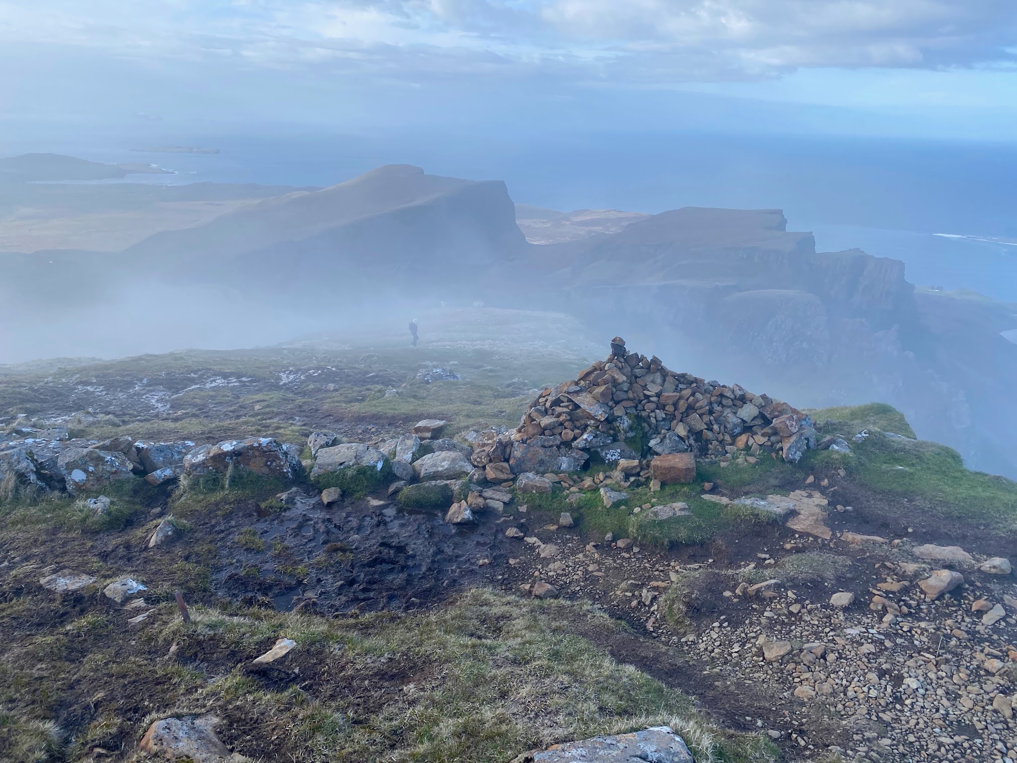
It was 5:30pm before we began the walk and the sun arrived at about the same time. Walkers were returning from the main attractions of the Needle and the Prison, both prominent rock outcrops resulting from massive landslips. The narrow path climbs at a gentle gradient. The views south along the Trotternish ridge were spectacular. We passed through the popular areas and turned left below an overhanging cliff to enter another area with rock towers scattered below massive cliffs. The number of walkers had declined and after passing through a gap in a drystone wall we entered another area of confused landscapes. Gregor had charged ahead and was walking along the top of the Sron Vourlinn cliff-edge as we climbed the final slopes to the gap in the cliffs. 

We met a party of Chinese students who were on a 5-day tour of Scotland before finishing their studies in Edinburgh. Fort William, Skye, Inverness and Oban were to be their overnight stops. They had not been walking very quickly when we had overtaken them on the ascent but they intrepidly began to walk out towards Sron Vourlinn. We continued to tackle the final 200 metres of ascent to the edge of the cliffs and I extended the walk to the summit of Meall na Suiramach. Its cairn set in the middle of a gentle convex slope was the antithesis of the scenery we had walked through. Some low clouds had reduced visibility but we could see and hear the rollers breaking on Staffin beach on a still spring evening.

Gregor left us at this stage to run down to the car park and then up the next peak on the Trotternish ridge, Biode Buidhe, and then down to Uig where we agreed to pick him up. The descent was tricky, first because of the low clouds and then a final 100-metre descent down a steep boggy path that challenged both the grip of footwear and knee joints. However, we were down in less than 3 hours and arrived in Uig only a few minutes ahead of Gregor. After the downpour of the morning, we had benefitted from the rapidly changing weather that is the essence of any trip to Skye.


Summit of Meall na Suiramach

Looking northeast to the Quiraing from the path

Looking south to the Trotternish ridge

The confused landscapes below the Sron Vourlinn cliffs

Sron Vourlinn escarpment 

Climbing through the cloud to the high point

Looking down on the Table

At the high point of the cliff edge, Staffin Bay below

Late evening arriving down from the summit plateau


Saturday, 1 May 2021

Canisp

Suilven from Canisp

Friday, 30 April 2021

Ascent:       750 metres
Distance:    12 kilometres
Time:          3 hours 31 minutes

Canisp        846m   1 hour 57 minutes

We were leaving Oldshoremore and travelling home after 4 nights in the Airbnb, the forecast was cold with winds, showers and snow predicted on the Mountains, my hopes of climbing Canisp were likely to be foiled. As a result, we dallied a little before leaving at 9:30am. I was attacked by the alsatian that escaped from a nearby caravan as I was loading the car and the apologies from its owner were the usual "it's just trying to be friendly". With its paws on my shoulders and its nose in my face, I was less certain. 

The drive through Scourie, past Badcall Bay, under the triptych of peaks that is Quinag was a delight, although we noticed that there were far more motor homes on the road now that we are approaching the first weekend after the easing of travel restrictions. We passed Inchnadamph with the snow cover on Conival down to 700 metres. But it was still dry and below the mainly grey skies, visibility was excellent. I parked at the layby east of Canisp at Loch Awe on the A837. Canisp looked nearer than it really was in the sharp light. I decided to go for it whilst Aileen would drive over to Lochinver for a couple of hours.

The boggy path crosses a footbridge and then provides a squishy cushion for the first kilometre as it traverses the numerous peaty watercourses. Eventually, it begins to climb and some quartzite provides a harder, sharper footfall.  There is a small hillock to climb over and the path drops slightly to a burn that runs directly towards the summit along an exquisite quartzite pavement. A large but fragile-looking cairn marks the end of this at 400 metres and then there is just the long pull up rocky slopes towards the shoulder of Canisp. I had been walking easily despite the exertions of the last few days and the benefits of the first break for 7 months seemed to be working.

The shoulder of Canisp provides that special moment when Suilven appears in all its primaeval glory. Ever since 1970 when I spent the summer working in the area it has been a totem for the craving to climb the mountains. But there are another 120 metres to climb and the summit is half a kilometre away, why is the highest point at the far end of the mountain? I blame the creationists! The weather had stayed dry but on arrival, there was a short shower of snow. I took a few photos and turned to make the descent, I had said I would be down by 2pm and despite keeping a good pace on the ascent, there was no time to hang about.

I decided not to put on my waterproof and it proved the right decision, there were occasional short flurries of snow or sleet but nothing to worry about. I was down for 2pm and after changing, we managed to make it to our friends on the Black Isle for tea and scones before 4pm. The evening drive down the A9 was remarkably quiet, in contrast to the traffic travelling north that was heavy as people headed to the north for the May weekend. I dread to think what the roads will be like in the summer as the motor homes head to the Mecca that is the North Coast 500.

The long ascent of Canisp

Quartzite pavement

The moment when Suilven appears

View from the top
Quinag in cloud

Cul Mor and Stac Pollaidh

Summit Shelter


Handa Island

Cliffs at the head of the path

Handa Island is a Nature Reserve run by the Scottish Wildlife Trust. We visited 40 years ago with our 11-month-old in a baby carrier as we dodged the Great Skuas walking across the island to the cliffs that host colonies of seabirds, It was one of those unforgettable memories from the magic of parenthood, our daughter's first word was "bird". We had hoped to visit again but it is a long journey north and we did not expect the reserve to be open so soon after lockdown eased. As we passed the road to Tarbert we noticed that the ferry was working so drove down more out of interest than any expectation. To our surprise, the RIB was running and better still the cafe was open so we were able to eat out for only the second time in six months whilst we waited for the RIB to return from its earlier trip. 

It is only a ten-minute journey across to Handa in the powerful RIB, far faster than the old motorboat. There was only us and a couple from Kent and their young son but 18 people had made the trip on the day, the busiest since the mobs of last summer. We landed on the beach where we were met by Johnny, the warden, and one of the volunteers who explained the island, the birdlife and some of the work of the volunteers. 

The sun had decided to welcome our arrival as we set out on the steady climb across the island to the cliffs at the northwest side. Numerous rabbits were nibbling the grass and burrows were everywhere. We passed the old shielings, the clearances had resulted in the inhabitants being transported to Canada. We followed the well-maintained path through the moorland where dozens of Great Skuas were establishing their nests. With no chicks to protect they were not yet into their attack phase and more interested in setting out their own territory from other pairs of birds. The path arrives at the cliff edge, 300 feet of red sandstone, with ledges occupied by razorbills, kittiwake and fulmars. The puffins had only just started arriving back and were presumably tidying out their burrows.

We had been told that there were regular visits from sea eagles that usually resulted in an air battle with the Skuas, but there were none today. Despite the cold temperature, the rays of the sun gave some warmth as we began the long return along the cliff edge. As the path descends there is a long winding boardwalk through the boggier ground. A working party were extending the boardwalk and explained the technicalities of construction to us. They were living in a bothy with a food delivery arriving every fortnight. They also warned us that the RIB had been grounded at Tarbert as a result of a very low spring tide and there would be no return journeys for an hour or so.

We sauntered back and spent time talking to the warden and other visitors before waiting on the beach for the RIB. We volunteered to go on the second trip as the capacity of the RIB was 12 and relaxed in the sand dunes for another twenty minutes. We decided to take the longer scenic route back from Tarbert by Fanogmore and Foindle and were rewarded by some wonderful scenery as the sea and inland lochans mingled with copses of yellow gorse. The Sutherland mountains had been hidden in the cloud until today now revealed themselves, adding wonder to what had been a perfect day.

Old Shielings

The path from the landing bay

Moorland path

Nesting Stack

Pathwork above the cliff

Kittiwake nesting


Great Wall

Kittiwake

Quinag in cloud

Great Skua protecting its territory

RIB in Sound of Handa

Rushing for the RIB at Port an Eilein

Tarbert Cafe

Ben Stack from Foindle

Arkle from Foindle